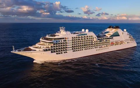
Seabourn7726A
35-Day Japan, Alaska, Glacier Bay & Pacific Crossing
Date
2027-04-24
Duration
35 nights
Departure Port
Tokyo
Japan
Arrival Port
Vancouver
Canada
Rating
Luxury
Theme
—
Date
2027-04-24
Duration
35 nights
Departure Port
Tokyo
Japan
Arrival Port
Vancouver
Canada
Rating
Luxury
Theme
—


Seabourn
2016
—
40,350 GT
600
266
330
690 m
28 m
19 knots
No

Tokyo's port is a vibrant gateway to both cultural and culinary experiences, uniquely blending traditional Japanese heritage with modern innovation. Must-do experiences include savoring fresh sushi at Tsukiji Outer Market and exploring the natural beauty of Fuji Hakone Izu National Park. The best season to visit is spring, when cherry blossoms bloom, transforming the city into a picturesque landscape.

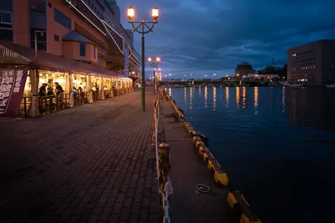
Hitachinaka, Japan, offers an immersion in a culture where aesthetic refinement and daily life are inseparable. Essential experiences include exploring local food markets, tasting regional specialties at intimate eateries, and visiting the surrounding temples and gardens. The port is most rewarding October through April, when cooler temperatures and lower humidity create ideal conditions. Cruise lines including Princess Cruises feature this port on their most compelling itineraries. Whether you have a few hours or a full day, the port rewards exploration at every pace and in every direction.

Ishinomaki on Japan's Sanriku coast has transformed from tsunami devastation into a symbol of resilience, offering visitors the whimsical Mangattan manga museum, some of Japan's finest oysters and seafood, and the sacred deer island of Kinkasan. Must-dos include the rebuilt fish market's morning sushi, the San Juan Bautista galleon replica, and walking the manga character-lined streets. May through October provides the best weather and seafood seasons.
Miyako is a resilient Pacific coast city in Japan's Tōhoku region, gateway to the dramatic Sanriku ria coastline and the ethereal Jōdogahama "Pure Land Beach" of white rock formations and turquoise water. Must-dos include boat tours through Jōdogahama's volcanic rock formations, visiting the 2011 tsunami memorial, and tasting the region's exceptional seafood including fresh uni and wakame. April through November offers varied seasonal beauty from cherry blossoms to autumn foliage.

Hakodate, Japan, offers an immersion in a culture where aesthetic refinement and daily life are inseparable. Essential experiences include exploring local food markets, tasting regional specialties at intimate eateries, and visiting the surrounding temples and gardens. The port is most rewarding May through October, when the climate is at its most welcoming for outdoor exploration. Cruise lines including Hapag-Lloyd Cruises feature this port on their most compelling itineraries. Whether you have a few hours or a full day, the port rewards exploration at every pace and in every direction.
Kushiro, on Hokkaido's wild eastern coast, is Japan's gateway to pristine marshlands, volcanic lakes, and the sacred red-crowned crane. The city's legendary Washo Market offers build-your-own sashimi bowls, while nearby Kushiro Shitsugen National Park protects the country's largest wetland. Silversea brings expedition travelers to this unhurried port where Ainu heritage and untamed nature converge.
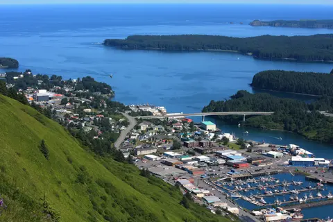
Kodiak, Alaska's oldest European settlement and one of America's largest fishing ports, sits on an island home to 3,500 giant Kodiak brown bears—the densest concentration on Earth. Must-dos include floatplane bear-viewing at remote salmon streams, the Alutiiq Museum of indigenous culture, and sampling king crab fresh from the harbor. July and August offer the warmest weather and peak bear-viewing season.

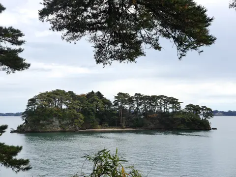
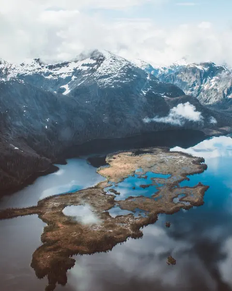
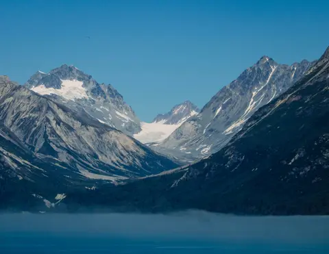
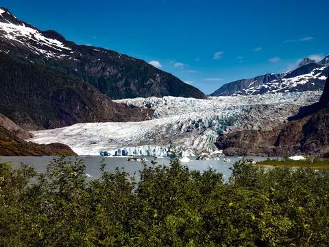
Glacier Bay National Park is one of the most profound landscapes of active glaciation on Earth — 3.3 million acres of southeastern Alaska where tidewater glaciers calve cathedral-sized icebergs into fjords of luminous blue water, and where the land itself is still rising, liberated from the weight of ice that buried this entire region just two centuries ago. The park, reachable only by ship or small aircraft, rewards visitors with wildlife encounters — humpback whales, brown bears, sea otters, and mountain goats — set against scenery of almost overwhelming grandeur. The season runs May through September; late June and July offer the longest days and most reliable wildlife activity.
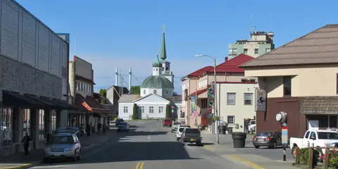
Sitka, set on the wild west coast of Baranof Island in Southeast Alaska, is one of the Pacific Northwest's most historically resonant ports — a place where Russian Orthodox onion domes rise above totem poles and the great temperate rainforest presses down to the water's edge. The Sitka National Historical Park preserves the site of the 1804 battle between Tlingit warriors and Russian colonisers alongside a magnificent collection of monumental poles. Whale-watching, sea kayaking among sea otters, and brown bear spotting in the surrounding wilderness define the outdoor experience. May through September offers the most accessible and luminous conditions.
Klawock is one of Alaska's oldest Tlingit settlements on Prince of Wales Island, where twenty-one totem poles in a community park narrate clan histories predating European contact by centuries. Visit May through September via Regent Seven Seas or Silversea for genuine Tlingit cultural encounters, Alaska's longest cave system, and the intimate experience of a remote island community where wilderness is neighbor, not commodity.
Prince Rupert, a historic railway terminus on British Columbia's northern coast, enchants visitors with its deep Tsimshian heritage, world-class halibut fishing, and misty rain forest scenery along the Inside Passage. Sample freshly smoked salmon at the waterfront and explore the North Pacific Cannery, Canada's oldest surviving cannery, for a vivid encounter with the port's maritime soul. The best time to visit is June through August, when longer days temper the famous rainfall and wildlife activity peaks along the coast.
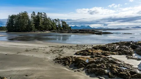
The upper latitudes of North America’s Pacific Coast are blessed with a long strand of islands scattered just offshore of the mainland. These islands provide shelter from the swells generated across the expanse of the world’s largest ocean, and offer one of the most scenic passages for ships to be found anywhere on the globe. Stretching from Washington State’s Puget Sound northward through British Columbia, Canada onward to the Panhandle of Southeast Alaska, it threads between forested islands and coastal mountain ranges, encompassing a total of over 45,000 miles of coastline, thousands of islands and innumerable coves. It is comprised of the Strait of Georgia, Johnstone Strait, the more open Hecate Strait near the Haida Gwai (formerly Queen Charlotte Islands), Fitz Hugh Sound, and the Princess Royal and Grenville Channels. These waterways are subject to tidal currents with variable velocity resulting from their restricted channels. At the northern end, diurnal tides can change the sea level by as much as 30 feet (9 meters), underlining the importance of using knowledgeable pilots during any passage. A wide variety of vessels pass through the Inside Passage in both directions. People on board enjoy the scenic land- and seascapes, as well as frequent sightings of wildlife including whales, seals, birds and occasionally bears. VIEW CRUISES
The Seymour Narrows is a 3-mile/5 km stretch of the Discovery Channel north of Vancouver Island, British Columbia that is notorious for the strength of the tidal currents flowing through it. The average width of the narrows is just 750 meters. During extreme tides, the current through the narrows is subject to severe Venturi effect, resulting in an increased velocity that can reach 15 knots. For much of its modern history, there was an additional hazard in the narrows called Ripple Rock, a shallow obstruction that claimed no fewer than 119 ships and 114 lives. In 1958, after months of tunneling and preparation, Ripple Rock was blown up in the largest commercial, non-nuclear explosion ever recorded in North America. Still, the navigation of Seymour Narrows is dependent on tidal and other conditions, and requires skill and technical accomplishment.

Pressed between the Pacific and the Coast Mountains, Vancouver is the natural gateway to Alaska's Inside Passage — a city where temperate rainforest meets glass towers and where Dungeness crab and wild sockeye salmon define a Pacific Rim cuisine that rivals any in North America. Walk the 22-kilometre Stanley Park seawall, lose yourself in the Granville Island market, then ferry across to Victoria's Edwardian splendour. Alaska cruise season peaks from May through September, making Vancouver an ideal starting point for one of the world's great ocean journeys.
The Queen Charlotte Sound lies between the Queen Charlotte Strait, which winds between Vancouver Island and the British Columbia mainland in the south, and Hecate Strait, which is northward, adjacent to the Haida Gwaii Islands off the Pacific coast of British Columbia. It is a broad reach in the long shipping route called the Inside Passage threading the myriad islands stretching from Washington’s Puget Sound to Alaska.
Ketchikan clings to the forested shore of Revillagigedo Island in Alaska's southeastern panhandle — a town so narrow that locals joke it is three miles long and three blocks wide. Revered by the Tlingit people for millennia as a place of abundant salmon, it is today celebrated as the Totem Pole Capital of the World: the collections at Saxman Native Village and Totem Bight State Historical Park preserve the most significant concentration of these monumental artworks anywhere. Creek Street, a boardwalk of colorful historic houses built over Ketchikan Creek, should not be missed. Summer (May–September) brings the best weather, with salmon running in the creeks below.
In the passage between Sumner Strait and Clarence Strait in Southeast Alaska’s Alexander Archipelago, midway between Price of Wales Island on the west and Zarembo Island on the east, is a small cluster of islands with a picturesque passageway between them called Snow Pass. It makes a scenic up-close route for your Seabourn ship during the transit.
Decision Passage is the western end of the Sumner Strait, which runs through the Alexander Archipelago into the Pacific Ocean in Southeastern Alaska, bounded on the north by Kuiu Island and Cape Decision, the location of a 1932 lighthouse. This is the route your ship takes when coming from or going to the colorful historic community of Sitka on the west coast of Baranof Island, which was originally the Russian fortress town of New Archangel.
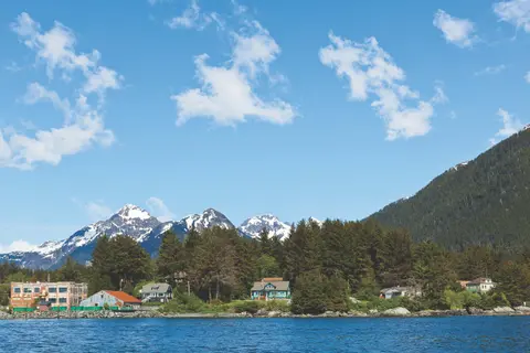
Sitka, set on the wild west coast of Baranof Island in Southeast Alaska, is one of the Pacific Northwest's most historically resonant ports — a place where Russian Orthodox onion domes rise above totem poles and the great temperate rainforest presses down to the water's edge. The Sitka National Historical Park preserves the site of the 1804 battle between Tlingit warriors and Russian colonisers alongside a magnificent collection of monumental poles. Whale-watching, sea kayaking among sea otters, and brown bear spotting in the surrounding wilderness define the outdoor experience. May through September offers the most accessible and luminous conditions.
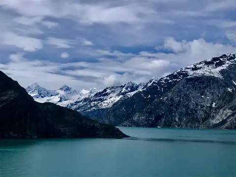
Glacier Bay National Park is one of the most profound landscapes of active glaciation on Earth — 3.3 million acres of southeastern Alaska where tidewater glaciers calve cathedral-sized icebergs into fjords of luminous blue water, and where the land itself is still rising, liberated from the weight of ice that buried this entire region just two centuries ago. The park, reachable only by ship or small aircraft, rewards visitors with wildlife encounters — humpback whales, brown bears, sea otters, and mountain goats — set against scenery of almost overwhelming grandeur. The season runs May through September; late June and July offer the longest days and most reliable wildlife activity.
The Inian Islands are a wild, uninhabited cluster at the entrance to Alaska's Cross Sound, renowned for extraordinary wildlife encounters including humpback whale bubble-net feeding and massive Steller sea lion colonies. Must-dos include Zodiac excursions along the islands' rocky shores, watching cooperative whale feeding, and exploring tide pools teeming with marine life. Visit July–August for peak whale activity and the best sea conditions.
Icy Strait Point is a stunning Alaskan port known for its breathtaking natural beauty and rich Native Tlingit culture. Must-do experiences include savoring fresh local seafood and embarking on wildlife excursions in Glacier Bay National Park. The best season to visit is during the summer months, when the weather is mild and wildlife is abundant.
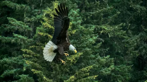
Haines is an authentic Alaskan town on North America's deepest fjord, home to the world's largest bald eagle congregation — up to four thousand birds along the Chilkat River — and a thriving arts community preserving Tlingit cultural traditions. Visit June through August via Cunard or Lindblad for glacier helicopter landings and coastal hikes, or October through February for the extraordinary eagle spectacle that makes Haines Alaska's best-kept secret.
America's only state capital unreachable by road, Juneau rewards the journey with a wilderness grandeur that few cities on earth can match. The Mendenhall Glacier — a living river of ancient ice — lies just fifteen minutes from downtown, where floatplanes dart above a waterfront flanked by spruce-draped mountains plunging straight into the sea. The must-do experience is a helicopter landing atop the icefield or a whale-watching excursion in Stephens Passage, where humpbacks breach in astonishing proximity. Juneau is warmest from June to August, though even summer days can bring the famous Southeast Alaska rain that keeps the rainforest perpetually luminous.
Glacier Bay National Park is one of the most profound landscapes of active glaciation on Earth — 3.3 million acres of southeastern Alaska where tidewater glaciers calve cathedral-sized icebergs into fjords of luminous blue water, and where the land itself is still rising, liberated from the weight of ice that buried this entire region just two centuries ago. The park, reachable only by ship or small aircraft, rewards visitors with wildlife encounters — humpback whales, brown bears, sea otters, and mountain goats — set against scenery of almost overwhelming grandeur. The season runs May through September; late June and July offer the longest days and most reliable wildlife activity.
Wrangell is one of Alaska's most authentic Inside Passage ports, where Tlingit heritage, ancient petroglyphs, and world-class wildlife converge at the mouth of the mighty Stikine River. Essential experiences include jet boating to LeConte Glacier, watching bears fish at Anan Creek, and tasting locally smoked salmon. July and August offer peak salmon runs and bear viewing.
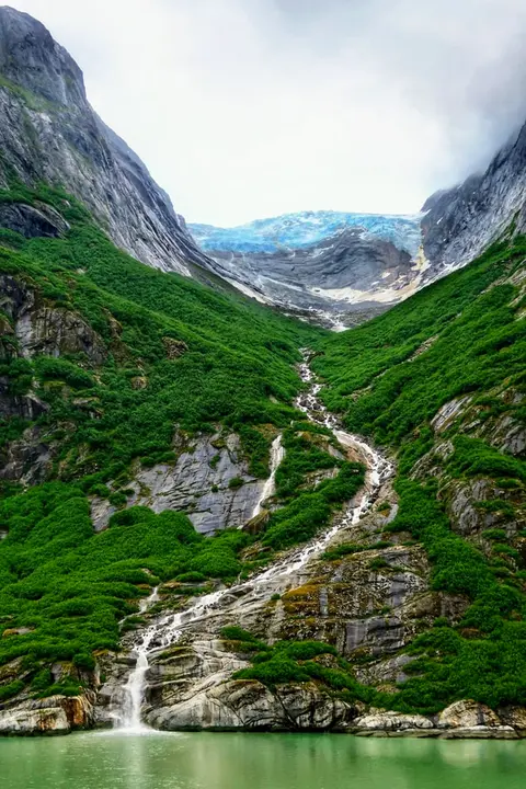
Misty Fjords National Monument is a 930,000-hectare wilderness in Southeast Alaska, where sheer granite cliffs rise from mirror-still fjords through perpetual veils of mist and cloud. Must-dos include kayaking through silent fjord arms, zodiac cruising past waterfalls and the volcanic New Eddystone Rock, and watching for bears, eagles, and orcas in the pristine channels. May through September offers the visiting season, with rain adding to the monument's ethereal atmosphere.
Misty Fjords National Monument is a section of the Tongass National Forest in Alaska’s extreme southeastern Panhandle region. The monument consists of over two million acres of deeply cut fjords cradled in U-shaped valleys between mountain ranges rising 2,000 to 3,000 feet above sea level. The fjords themselves extend as much as 1,000 feet below the surface. These granite ranges are covered with virgin forest, and most of the monument is also a dedicated wilderness area. Misty Fjords inspired the explorer John Muir to proclaim them among the most beautiful places he had ever seen. Your ship will cruise among these spectacular forests, waterfalls and mountains. The onboard Ventures by Seabourn team will offer optional excursions including kayaking the fjords and a short sightseeing floatplane flight.
Prince Rupert, a historic railway terminus on British Columbia's northern coast, enchants visitors with its deep Tsimshian heritage, world-class halibut fishing, and misty rain forest scenery along the Inside Passage. Sample freshly smoked salmon at the waterfront and explore the North Pacific Cannery, Canada's oldest surviving cannery, for a vivid encounter with the port's maritime soul. The best time to visit is June through August, when longer days temper the famous rainfall and wildlife activity peaks along the coast.
Grenville Channel is a long, well-protected channel along the northern British Columbia coast between the large Pitt Island and the mainland. It is an important shipping lane, and you are likely to see ships of many different types and sizes as you pass through. The shores are mountainous on both sides, with two notable peaks about halfway through, Mt. Batchellor on the east side and Mt. Saunders on Pitt Island to the west. There are a number of Indian Reserves and Marine Parks in the mountains and narrow waterways off the channel.
Whale Channel is a picturesque waterway separating Gil Island from Princess Royal Island in British Columbia’s Inside Passage. Surrounded by snow-capped mountain ranges and teeming with marine life, It is a diversion from the main shipping lane, located roughly halfway between Prince Rupert and the First Nations village of Klemtu. VIEW CRUISES Skip Footer Content About Us
The Princess Royal Channel separates the largest island along British Columbia’s coast from the mainland. It is located roughly halfway between Bella Bella in the south and Prince Rupert in the north, in one of the province’s most remote areas. Princess Royal island was named in 1788 by Captain Charles Duncan, in honor of his ship, the Princess Royal. The island is uninhabited, although there are two small villages in the channel, the First Nations community of Klemtu on Swindle Island and Hartley Bay on the mainland. Wildlife, by contrast, is plentiful, including Kermode, black and grizzly bears, deer, wolves and foxes. Golden and bald eagles nest in the region, as well as the endangered marbled murrelet. In the waters, there are abundant salmon, elephant seals, whales, orcas and dolphins.
Alert Bay, Canada is a distinctive port city where deep cultural heritage meets authentic local atmosphere, featured on itineraries by HX Expeditions. Must-do experiences include walking the historic center to experience the layered architectural heritage, and seeking out the regional culinary traditions at a locally favored establishment away from the port area. The optimal time to visit is June through August, when summer months bring the warmest temperatures and longest days.
Johnstone Strait is a well-protected shipping route passing 68 miles/110 km along the northeast shore of Vancouver Island between the island and the mainland of British Columbia. The strait is between 1 ½ miles and 3 miles wide, and leads from the broad Georgia Strait through a narrow channel called Discovery Passage. The strait was named by Vancouver in 1792 for James Johnstone, the master of one of his tenders during the survey expedition that revealed Vancouver Island to be an island. There are no cities or towns on the strait. The Johnstone Strait is the summer range of a large pod of seasonally resident orcas which are frequently seen in the area. VIEW CRUISES Skip Footer Content About Us Our Company News Careers Contact Us Video Gallery Accessibility Seabourn Club Seabourn Referral Program Travel Resources
The Seymour Narrows is a 3-mile/5 km stretch of the Discovery Channel north of Vancouver Island, British Columbia that is notorious for the strength of the tidal currents flowing through it. The average width of the narrows is just 750 meters. During extreme tides, the current through the narrows is subject to severe Venturi effect, resulting in an increased velocity that can reach 15 knots. For much of its modern history, there was an additional hazard in the narrows called Ripple Rock, a shallow obstruction that claimed no fewer than 119 ships and 114 lives. In 1958, after months of tunneling and preparation, Ripple Rock was blown up in the largest commercial, non-nuclear explosion ever recorded in North America. Still, the navigation of Seymour Narrows is dependent on tidal and other conditions, and requires skill and technical accomplishment.
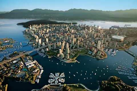
Pressed between the Pacific and the Coast Mountains, Vancouver is the natural gateway to Alaska's Inside Passage — a city where temperate rainforest meets glass towers and where Dungeness crab and wild sockeye salmon define a Pacific Rim cuisine that rivals any in North America. Walk the 22-kilometre Stanley Park seawall, lose yourself in the Granville Island market, then ferry across to Victoria's Edwardian splendour. Alaska cruise season peaks from May through September, making Vancouver an ideal starting point for one of the world's great ocean journeys.
Day 1
Tokyo's port is a vibrant gateway to both cultural and culinary experiences, uniquely blending traditional Japanese heritage with modern innovation. Must-do experiences include savoring fresh sushi at Tsukiji Outer Market and exploring the natural beauty of Fuji Hakone Izu National Park. The best season to visit is spring, when cherry blossoms bloom, transforming the city into a picturesque landscape.
Day 2
Hitachinaka, Japan, offers an immersion in a culture where aesthetic refinement and daily life are inseparable. Essential experiences include exploring local food markets, tasting regional specialties at intimate eateries, and visiting the surrounding temples and gardens. The port is most rewarding October through April, when cooler temperatures and lower humidity create ideal conditions. Cruise lines including Princess Cruises feature this port on their most compelling itineraries. Whether you have a few hours or a full day, the port rewards exploration at every pace and in every direction.
Day 3
Ishinomaki on Japan's Sanriku coast has transformed from tsunami devastation into a symbol of resilience, offering visitors the whimsical Mangattan manga museum, some of Japan's finest oysters and seafood, and the sacred deer island of Kinkasan. Must-dos include the rebuilt fish market's morning sushi, the San Juan Bautista galleon replica, and walking the manga character-lined streets. May through October provides the best weather and seafood seasons.
Day 4
Miyako is a resilient Pacific coast city in Japan's Tōhoku region, gateway to the dramatic Sanriku ria coastline and the ethereal Jōdogahama "Pure Land Beach" of white rock formations and turquoise water. Must-dos include boat tours through Jōdogahama's volcanic rock formations, visiting the 2011 tsunami memorial, and tasting the region's exceptional seafood including fresh uni and wakame. April through November offers varied seasonal beauty from cherry blossoms to autumn foliage.
Day 5
Hakodate, Japan, offers an immersion in a culture where aesthetic refinement and daily life are inseparable. Essential experiences include exploring local food markets, tasting regional specialties at intimate eateries, and visiting the surrounding temples and gardens. The port is most rewarding May through October, when the climate is at its most welcoming for outdoor exploration. Cruise lines including Hapag-Lloyd Cruises feature this port on their most compelling itineraries. Whether you have a few hours or a full day, the port rewards exploration at every pace and in every direction.
Day 6
Kushiro, on Hokkaido's wild eastern coast, is Japan's gateway to pristine marshlands, volcanic lakes, and the sacred red-crowned crane. The city's legendary Washo Market offers build-your-own sashimi bowls, while nearby Kushiro Shitsugen National Park protects the country's largest wetland. Silversea brings expedition travelers to this unhurried port where Ainu heritage and untamed nature converge.
Day 7
Day 8
Day 9
Day 10
Day 11
Day 12
Day 13
Day 14
Day 15
Kodiak, Alaska's oldest European settlement and one of America's largest fishing ports, sits on an island home to 3,500 giant Kodiak brown bears—the densest concentration on Earth. Must-dos include floatplane bear-viewing at remote salmon streams, the Alutiiq Museum of indigenous culture, and sampling king crab fresh from the harbor. July and August offer the warmest weather and peak bear-viewing season.
Day 16
Day 17
Glacier Bay National Park is one of the most profound landscapes of active glaciation on Earth — 3.3 million acres of southeastern Alaska where tidewater glaciers calve cathedral-sized icebergs into fjords of luminous blue water, and where the land itself is still rising, liberated from the weight of ice that buried this entire region just two centuries ago. The park, reachable only by ship or small aircraft, rewards visitors with wildlife encounters — humpback whales, brown bears, sea otters, and mountain goats — set against scenery of almost overwhelming grandeur. The season runs May through September; late June and July offer the longest days and most reliable wildlife activity.
Day 18
Sitka, set on the wild west coast of Baranof Island in Southeast Alaska, is one of the Pacific Northwest's most historically resonant ports — a place where Russian Orthodox onion domes rise above totem poles and the great temperate rainforest presses down to the water's edge. The Sitka National Historical Park preserves the site of the 1804 battle between Tlingit warriors and Russian colonisers alongside a magnificent collection of monumental poles. Whale-watching, sea kayaking among sea otters, and brown bear spotting in the surrounding wilderness define the outdoor experience. May through September offers the most accessible and luminous conditions.
Day 19
Klawock is one of Alaska's oldest Tlingit settlements on Prince of Wales Island, where twenty-one totem poles in a community park narrate clan histories predating European contact by centuries. Visit May through September via Regent Seven Seas or Silversea for genuine Tlingit cultural encounters, Alaska's longest cave system, and the intimate experience of a remote island community where wilderness is neighbor, not commodity.
Day 20
Prince Rupert, a historic railway terminus on British Columbia's northern coast, enchants visitors with its deep Tsimshian heritage, world-class halibut fishing, and misty rain forest scenery along the Inside Passage. Sample freshly smoked salmon at the waterfront and explore the North Pacific Cannery, Canada's oldest surviving cannery, for a vivid encounter with the port's maritime soul. The best time to visit is June through August, when longer days temper the famous rainfall and wildlife activity peaks along the coast.
Day 21
The upper latitudes of North America’s Pacific Coast are blessed with a long strand of islands scattered just offshore of the mainland. These islands provide shelter from the swells generated across the expanse of the world’s largest ocean, and offer one of the most scenic passages for ships to be found anywhere on the globe. Stretching from Washington State’s Puget Sound northward through British Columbia, Canada onward to the Panhandle of Southeast Alaska, it threads between forested islands and coastal mountain ranges, encompassing a total of over 45,000 miles of coastline, thousands of islands and innumerable coves. It is comprised of the Strait of Georgia, Johnstone Strait, the more open Hecate Strait near the Haida Gwai (formerly Queen Charlotte Islands), Fitz Hugh Sound, and the Princess Royal and Grenville Channels. These waterways are subject to tidal currents with variable velocity resulting from their restricted channels. At the northern end, diurnal tides can change the sea level by as much as 30 feet (9 meters), underlining the importance of using knowledgeable pilots during any passage. A wide variety of vessels pass through the Inside Passage in both directions. People on board enjoy the scenic land- and seascapes, as well as frequent sightings of wildlife including whales, seals, birds and occasionally bears. VIEW CRUISES
The Seymour Narrows is a 3-mile/5 km stretch of the Discovery Channel north of Vancouver Island, British Columbia that is notorious for the strength of the tidal currents flowing through it. The average width of the narrows is just 750 meters. During extreme tides, the current through the narrows is subject to severe Venturi effect, resulting in an increased velocity that can reach 15 knots. For much of its modern history, there was an additional hazard in the narrows called Ripple Rock, a shallow obstruction that claimed no fewer than 119 ships and 114 lives. In 1958, after months of tunneling and preparation, Ripple Rock was blown up in the largest commercial, non-nuclear explosion ever recorded in North America. Still, the navigation of Seymour Narrows is dependent on tidal and other conditions, and requires skill and technical accomplishment.
Day 22
Pressed between the Pacific and the Coast Mountains, Vancouver is the natural gateway to Alaska's Inside Passage — a city where temperate rainforest meets glass towers and where Dungeness crab and wild sockeye salmon define a Pacific Rim cuisine that rivals any in North America. Walk the 22-kilometre Stanley Park seawall, lose yourself in the Granville Island market, then ferry across to Victoria's Edwardian splendour. Alaska cruise season peaks from May through September, making Vancouver an ideal starting point for one of the world's great ocean journeys.
Day 23
The Queen Charlotte Sound lies between the Queen Charlotte Strait, which winds between Vancouver Island and the British Columbia mainland in the south, and Hecate Strait, which is northward, adjacent to the Haida Gwaii Islands off the Pacific coast of British Columbia. It is a broad reach in the long shipping route called the Inside Passage threading the myriad islands stretching from Washington’s Puget Sound to Alaska.
Day 24
Ketchikan clings to the forested shore of Revillagigedo Island in Alaska's southeastern panhandle — a town so narrow that locals joke it is three miles long and three blocks wide. Revered by the Tlingit people for millennia as a place of abundant salmon, it is today celebrated as the Totem Pole Capital of the World: the collections at Saxman Native Village and Totem Bight State Historical Park preserve the most significant concentration of these monumental artworks anywhere. Creek Street, a boardwalk of colorful historic houses built over Ketchikan Creek, should not be missed. Summer (May–September) brings the best weather, with salmon running in the creeks below.
In the passage between Sumner Strait and Clarence Strait in Southeast Alaska’s Alexander Archipelago, midway between Price of Wales Island on the west and Zarembo Island on the east, is a small cluster of islands with a picturesque passageway between them called Snow Pass. It makes a scenic up-close route for your Seabourn ship during the transit.
Decision Passage is the western end of the Sumner Strait, which runs through the Alexander Archipelago into the Pacific Ocean in Southeastern Alaska, bounded on the north by Kuiu Island and Cape Decision, the location of a 1932 lighthouse. This is the route your ship takes when coming from or going to the colorful historic community of Sitka on the west coast of Baranof Island, which was originally the Russian fortress town of New Archangel.
Day 25
Sitka, set on the wild west coast of Baranof Island in Southeast Alaska, is one of the Pacific Northwest's most historically resonant ports — a place where Russian Orthodox onion domes rise above totem poles and the great temperate rainforest presses down to the water's edge. The Sitka National Historical Park preserves the site of the 1804 battle between Tlingit warriors and Russian colonisers alongside a magnificent collection of monumental poles. Whale-watching, sea kayaking among sea otters, and brown bear spotting in the surrounding wilderness define the outdoor experience. May through September offers the most accessible and luminous conditions.
Day 26
Glacier Bay National Park is one of the most profound landscapes of active glaciation on Earth — 3.3 million acres of southeastern Alaska where tidewater glaciers calve cathedral-sized icebergs into fjords of luminous blue water, and where the land itself is still rising, liberated from the weight of ice that buried this entire region just two centuries ago. The park, reachable only by ship or small aircraft, rewards visitors with wildlife encounters — humpback whales, brown bears, sea otters, and mountain goats — set against scenery of almost overwhelming grandeur. The season runs May through September; late June and July offer the longest days and most reliable wildlife activity.
Day 27
The Inian Islands are a wild, uninhabited cluster at the entrance to Alaska's Cross Sound, renowned for extraordinary wildlife encounters including humpback whale bubble-net feeding and massive Steller sea lion colonies. Must-dos include Zodiac excursions along the islands' rocky shores, watching cooperative whale feeding, and exploring tide pools teeming with marine life. Visit July–August for peak whale activity and the best sea conditions.
Icy Strait Point is a stunning Alaskan port known for its breathtaking natural beauty and rich Native Tlingit culture. Must-do experiences include savoring fresh local seafood and embarking on wildlife excursions in Glacier Bay National Park. The best season to visit is during the summer months, when the weather is mild and wildlife is abundant.
Day 28
Haines is an authentic Alaskan town on North America's deepest fjord, home to the world's largest bald eagle congregation — up to four thousand birds along the Chilkat River — and a thriving arts community preserving Tlingit cultural traditions. Visit June through August via Cunard or Lindblad for glacier helicopter landings and coastal hikes, or October through February for the extraordinary eagle spectacle that makes Haines Alaska's best-kept secret.
Day 29
America's only state capital unreachable by road, Juneau rewards the journey with a wilderness grandeur that few cities on earth can match. The Mendenhall Glacier — a living river of ancient ice — lies just fifteen minutes from downtown, where floatplanes dart above a waterfront flanked by spruce-draped mountains plunging straight into the sea. The must-do experience is a helicopter landing atop the icefield or a whale-watching excursion in Stephens Passage, where humpbacks breach in astonishing proximity. Juneau is warmest from June to August, though even summer days can bring the famous Southeast Alaska rain that keeps the rainforest perpetually luminous.
Day 30
Glacier Bay National Park is one of the most profound landscapes of active glaciation on Earth — 3.3 million acres of southeastern Alaska where tidewater glaciers calve cathedral-sized icebergs into fjords of luminous blue water, and where the land itself is still rising, liberated from the weight of ice that buried this entire region just two centuries ago. The park, reachable only by ship or small aircraft, rewards visitors with wildlife encounters — humpback whales, brown bears, sea otters, and mountain goats — set against scenery of almost overwhelming grandeur. The season runs May through September; late June and July offer the longest days and most reliable wildlife activity.
Day 31
Wrangell is one of Alaska's most authentic Inside Passage ports, where Tlingit heritage, ancient petroglyphs, and world-class wildlife converge at the mouth of the mighty Stikine River. Essential experiences include jet boating to LeConte Glacier, watching bears fish at Anan Creek, and tasting locally smoked salmon. July and August offer peak salmon runs and bear viewing.
Day 32
Misty Fjords National Monument is a 930,000-hectare wilderness in Southeast Alaska, where sheer granite cliffs rise from mirror-still fjords through perpetual veils of mist and cloud. Must-dos include kayaking through silent fjord arms, zodiac cruising past waterfalls and the volcanic New Eddystone Rock, and watching for bears, eagles, and orcas in the pristine channels. May through September offers the visiting season, with rain adding to the monument's ethereal atmosphere.
Misty Fjords National Monument is a section of the Tongass National Forest in Alaska’s extreme southeastern Panhandle region. The monument consists of over two million acres of deeply cut fjords cradled in U-shaped valleys between mountain ranges rising 2,000 to 3,000 feet above sea level. The fjords themselves extend as much as 1,000 feet below the surface. These granite ranges are covered with virgin forest, and most of the monument is also a dedicated wilderness area. Misty Fjords inspired the explorer John Muir to proclaim them among the most beautiful places he had ever seen. Your ship will cruise among these spectacular forests, waterfalls and mountains. The onboard Ventures by Seabourn team will offer optional excursions including kayaking the fjords and a short sightseeing floatplane flight.
Day 33
Prince Rupert, a historic railway terminus on British Columbia's northern coast, enchants visitors with its deep Tsimshian heritage, world-class halibut fishing, and misty rain forest scenery along the Inside Passage. Sample freshly smoked salmon at the waterfront and explore the North Pacific Cannery, Canada's oldest surviving cannery, for a vivid encounter with the port's maritime soul. The best time to visit is June through August, when longer days temper the famous rainfall and wildlife activity peaks along the coast.
Day 34
Grenville Channel is a long, well-protected channel along the northern British Columbia coast between the large Pitt Island and the mainland. It is an important shipping lane, and you are likely to see ships of many different types and sizes as you pass through. The shores are mountainous on both sides, with two notable peaks about halfway through, Mt. Batchellor on the east side and Mt. Saunders on Pitt Island to the west. There are a number of Indian Reserves and Marine Parks in the mountains and narrow waterways off the channel.
Whale Channel is a picturesque waterway separating Gil Island from Princess Royal Island in British Columbia’s Inside Passage. Surrounded by snow-capped mountain ranges and teeming with marine life, It is a diversion from the main shipping lane, located roughly halfway between Prince Rupert and the First Nations village of Klemtu. VIEW CRUISES Skip Footer Content About Us
The Princess Royal Channel separates the largest island along British Columbia’s coast from the mainland. It is located roughly halfway between Bella Bella in the south and Prince Rupert in the north, in one of the province’s most remote areas. Princess Royal island was named in 1788 by Captain Charles Duncan, in honor of his ship, the Princess Royal. The island is uninhabited, although there are two small villages in the channel, the First Nations community of Klemtu on Swindle Island and Hartley Bay on the mainland. Wildlife, by contrast, is plentiful, including Kermode, black and grizzly bears, deer, wolves and foxes. Golden and bald eagles nest in the region, as well as the endangered marbled murrelet. In the waters, there are abundant salmon, elephant seals, whales, orcas and dolphins.
Day 35
Alert Bay, Canada is a distinctive port city where deep cultural heritage meets authentic local atmosphere, featured on itineraries by HX Expeditions. Must-do experiences include walking the historic center to experience the layered architectural heritage, and seeking out the regional culinary traditions at a locally favored establishment away from the port area. The optimal time to visit is June through August, when summer months bring the warmest temperatures and longest days.
Johnstone Strait is a well-protected shipping route passing 68 miles/110 km along the northeast shore of Vancouver Island between the island and the mainland of British Columbia. The strait is between 1 ½ miles and 3 miles wide, and leads from the broad Georgia Strait through a narrow channel called Discovery Passage. The strait was named by Vancouver in 1792 for James Johnstone, the master of one of his tenders during the survey expedition that revealed Vancouver Island to be an island. There are no cities or towns on the strait. The Johnstone Strait is the summer range of a large pod of seasonally resident orcas which are frequently seen in the area. VIEW CRUISES Skip Footer Content About Us Our Company News Careers Contact Us Video Gallery Accessibility Seabourn Club Seabourn Referral Program Travel Resources
The Seymour Narrows is a 3-mile/5 km stretch of the Discovery Channel north of Vancouver Island, British Columbia that is notorious for the strength of the tidal currents flowing through it. The average width of the narrows is just 750 meters. During extreme tides, the current through the narrows is subject to severe Venturi effect, resulting in an increased velocity that can reach 15 knots. For much of its modern history, there was an additional hazard in the narrows called Ripple Rock, a shallow obstruction that claimed no fewer than 119 ships and 114 lives. In 1958, after months of tunneling and preparation, Ripple Rock was blown up in the largest commercial, non-nuclear explosion ever recorded in North America. Still, the navigation of Seymour Narrows is dependent on tidal and other conditions, and requires skill and technical accomplishment.
Day 36
Pressed between the Pacific and the Coast Mountains, Vancouver is the natural gateway to Alaska's Inside Passage — a city where temperate rainforest meets glass towers and where Dungeness crab and wild sockeye salmon define a Pacific Rim cuisine that rivals any in North America. Walk the 22-kilometre Stanley Park seawall, lose yourself in the Granville Island market, then ferry across to Victoria's Edwardian splendour. Alaska cruise season peaks from May through September, making Vancouver an ideal starting point for one of the world's great ocean journeys.


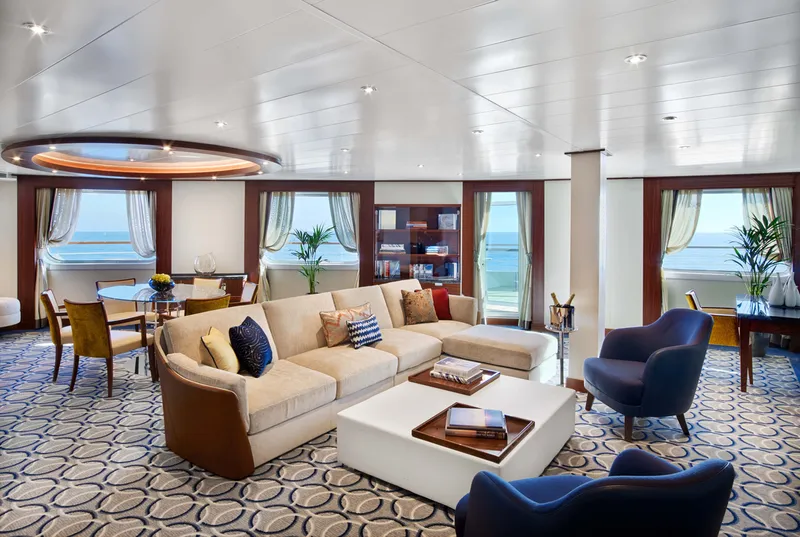
Located on Deck 8; Combine mid-ship suites 849 and 851 for suite 8491 or suites 846 and 848 for suite 8468 for a total inside space of 1,292 square feet (120 square meters) plus two verandas totaling 244 square feet (23 square meters)
Grand Wintergarden Suites feature
Large windows
Dining for six
Glass-enclosed solarium with tub and day bed
Two bedrooms
Two bathrooms (one whirlpool)
Convertible sofa bed for one
Pantry with wet bar
Two flat-screen TVs
Complimentary Internet/Wi-Fi service

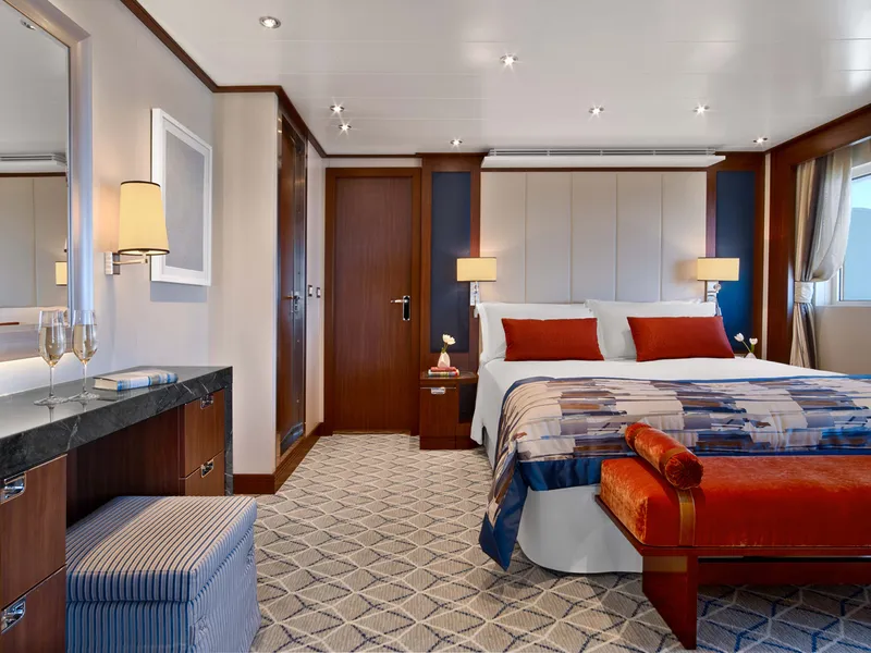
Located on Deck 7, 8, 9 and 10; total inside space of between 576 and 597 square feet (54 and 55 square meters) plus veranda of between 142 and 778 square feet (13 and 72 square meters).
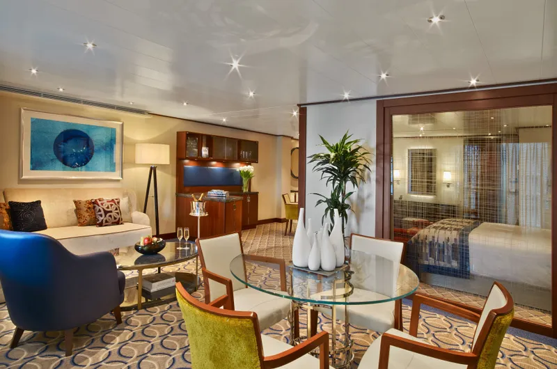
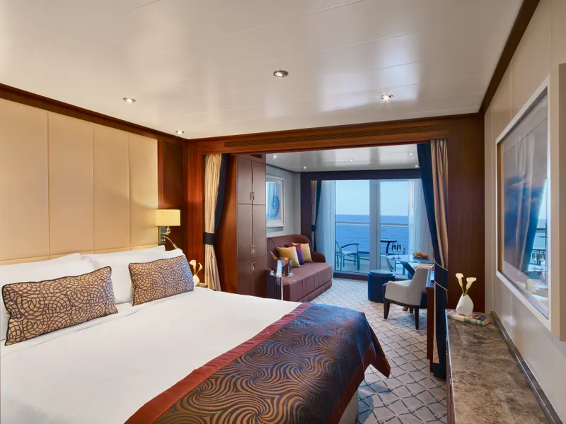
Owner's Suites feature:
Expansive ocean views
Forward-facing windows
Dining for four to six
Bathroom with whirlpool bathtub
Guest bath
Pantry with wet bar
Two flat-screen TVs
Complimentary Internet/Wi-Fi service.
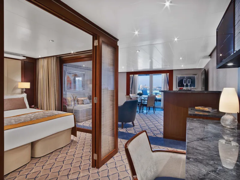


Penthouse Spa Suite
Located on Deck 11; total inside space of between 639 and 677 square feet (59 and 63 square meters) plus veranda of between 254 and 288 square feet (24 and 27 square meters)
All Penthouse Spa Suites feature
Dining table for two to four
Separate bedroom
Glass door to veranda
Two flat-screen TVs
Fully stocked bar
Spacious bathroom with tub, shower and large vanity
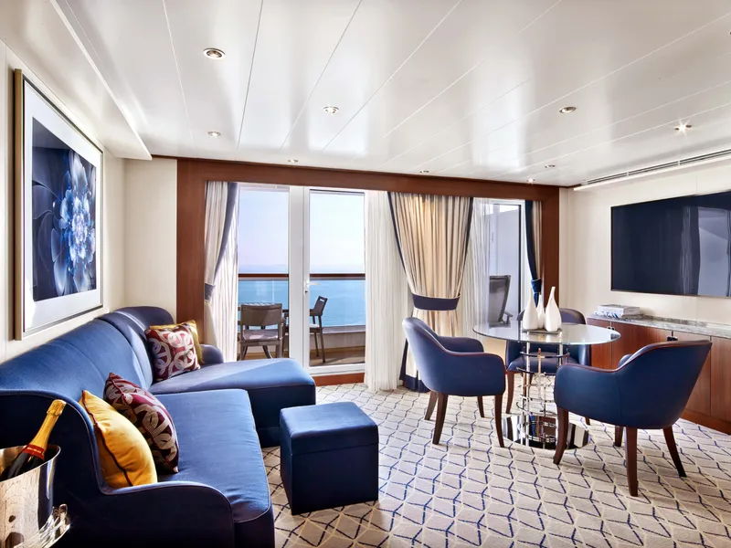

Located on Deck 10 and 11; total inside space of between 449 and 450 square feet (42 square meters) plus one veranda of between 93 and 103 square feet (9 and 10 square meters)
All Penthouse Suites feature:
Dining table for two to four
Separate bedroom
Glass door to veranda
Two flat-screen TVs
Fully stocked bar
Spacious bathroom with tub, shower and large vanity

Located on Deck 8; forward suites 800 and 801 inside space of approximately 977 square feet of inside space (90 square meters), plus one veranda of 960 square feet (89 square meters).
Signature Suites feature
Expansive ocean views
Forward-facing windows
Dining for four to six
Bathroom with whirlpool bathtub
Guest bath
Pantry with wet bar
Two flat-screen TVs
Complimentary Internet/Wi-Fi service


Located on Deck 8; mid-ship suites 846 and 849 inside space of 989 square feet (92 square meters) plus one veranda of 197 square feet (18 square meters)
Wintergarden Suites feature:
Large windows
Dining for six
Whirlpool bathtub
Guest bath
Convertible sofa bed for one
Pantry with wet bar
Glass-enclosed solarium with tub and day bed
Two closets
Two flat-screen TVs
Complimentary Internet/Wi-Fi service.

Single Veranda Suite Guarantee


Located on Deck 6, Deck 7, Deck 8, Deck 9, total inside space of between 246 and 302 square feet (23 and 28 square meters) plus one veranda of between 68 and 83 square feet (6 and 7 square meters)
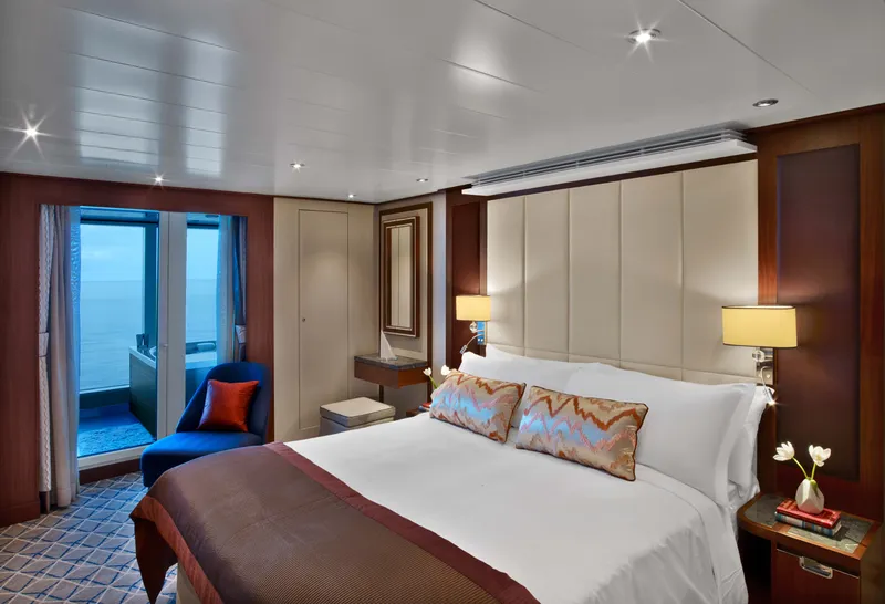
All Veranda Suites feature
A full-length window.
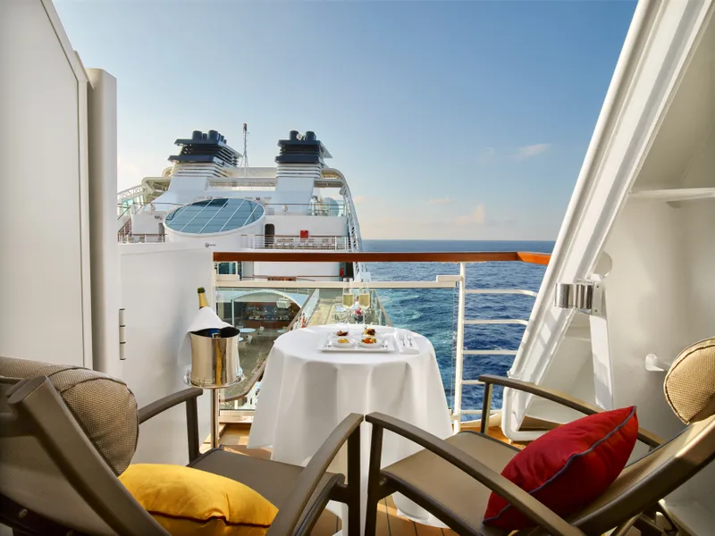
Glass door to private veranda.
Comfortable living area.
Queen-size bed or two twin beds.
Dining table for two.
Walk-in closet.
Interactive flat-screen television with music and movies.
Fully stocked bar and refrigerator.
Makeup vanity.
Spacious bathroom with separate tub and shower.


VERANDA SUITE GUARANTEE
Our cruise specialists can help you find the perfect cabin and the best available pricing.
(+886) 02-2721-7300Contact Advisor