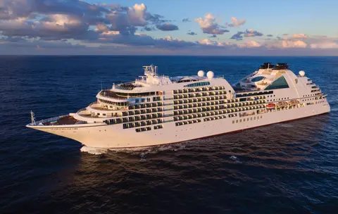
Seabourn7731
7 Днів Льодовиків та Внутрішній Прохід Аляски
Date
2027-05-28
Duration
7 nights
Departure Port
Ванкувер
Канада
Arrival Port
Джуно
Сполучені Штати
Rating
—
Theme
—
Date
2027-05-28
Duration
7 nights
Departure Port
Ванкувер
Канада
Arrival Port
Джуно
Сполучені Штати
Rating
—
Theme
—





Seabourn
2016
—
40,350 GT
600
266
330
690 m
28 m
19 knots
No
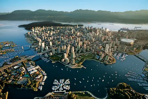
Стиснуте між Тихим океаном і Прибережними горами, Ванкувер є природними воротами до Внутрішнього проходу Аляски — містом, де помірний дощовий ліс зустрічається зі скляними вежами, а краби Дандженес і дикий червоний лосось визначають кухню Тихоокеанського узбережжя, яка може змагатися з будь-якою в Північній Америці. Прогуляйтеся 22-кілометровою набережною Стенлі-парку, загубіться на ринку Гранвілл-Айленд, а потім переправтеся на паром до елегантності Вікторії епохи едуардіанців. Сезон круїзів до Аляски досягає піку з травня по вересень, що робить Ванкувер ідеальною відправною точкою для однієї з великих океанських подорожей світу.
The Seymour Narrows is a 3-mile/5 km stretch of the Discovery Channel north of Vancouver Island, British Columbia that is notorious for the strength of the tidal currents flowing through it. The average width of the narrows is just 750 meters. During extreme tides, the current through the narrows is subject to severe Venturi effect, resulting in an increased velocity that can reach 15 knots. For much of its modern history, there was an additional hazard in the narrows called Ripple Rock, a shallow obstruction that claimed no fewer than 119 ships and 114 lives. In 1958, after months of tunneling and preparation, Ripple Rock was blown up in the largest commercial, non-nuclear explosion ever recorded in North America. Still, the navigation of Seymour Narrows is dependent on tidal and other conditions, and requires skill and technical accomplishment.
The Queen Charlotte Sound lies between the Queen Charlotte Strait, which winds between Vancouver Island and the British Columbia mainland in the south, and Hecate Strait, which is northward, adjacent to the Haida Gwaii Islands off the Pacific coast of British Columbia. It is a broad reach in the long shipping route called the Inside Passage threading the myriad islands stretching from Washington’s Puget Sound to Alaska.
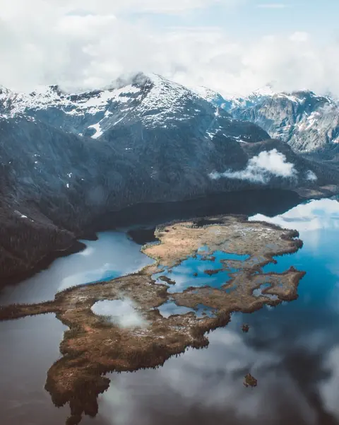
Кетчікан тримається за лісистий берег острова Ревільягідо в південно-східній частині Аляски — місто таке вузьке, що місцеві жителі жартують, що воно три милі завдовжки і три квартали завширшки. Впродовж тисячоліть його шанували народи Тлінгіт як місце, багате на лосося, а сьогодні його відзначають як Столицю тотемних стовпів світу: колекції в селі корінних народів Саксмана та державному історичному парку Тотем Байт зберігають найбільшу концентрацію цих монументальних витворів мистецтва у світі. Вулиця Крик, пішохідна доріжка кольорових історичних будинків, побудованих над Кетчіканом Крик, не повинна бути пропущена. Літо (травень-вересень) приносить найкращу погоду, з лососем, що пливе в ріках нижче.
In the passage between Sumner Strait and Clarence Strait in Southeast Alaska’s Alexander Archipelago, midway between Price of Wales Island on the west and Zarembo Island on the east, is a small cluster of islands with a picturesque passageway between them called Snow Pass. It makes a scenic up-close route for your Seabourn ship during the transit.
Decision Passage is the western end of the Sumner Strait, which runs through the Alexander Archipelago into the Pacific Ocean in Southeastern Alaska, bounded on the north by Kuiu Island and Cape Decision, the location of a 1932 lighthouse. This is the route your ship takes when coming from or going to the colorful historic community of Sitka on the west coast of Baranof Island, which was originally the Russian fortress town of New Archangel.
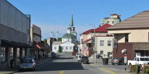
Сітка, розташована на дикому західному узбережжі острова Бараноф у Південному Алясці, є одним з найісторичніших портів Тихоокеанського Північного Заходу — місцем, де російські православні цибулинні куполи підносяться над тотемними стовпами, а великий помірний тропічний ліс спускається до краю води. Національний історичний парк Сітки зберігає місце битви 1804 року між воїнами Тлінгіт та російськими колонізаторами поряд з чудовою колекцією монументальних стовпів. Спостереження за китами, каякінг серед морських видр та спостереження за бурими ведмедями в навколишній дикій природі визначають досвід на відкритому повітрі. З травня по вересень пропонує найзручніші та найяскравіші умови.
Yakutat Bay is 18 miles wide at its entry, and cuts from the Gulf of Alaska into Disenchantment Bay, the entryway to the huge Hubbard Glacier, North America’s largest tidewater glacier. As the bay narrows and the shorelines draw closer, the 400-foot face of the glacier exerts a luminous, ghostly presence, often from as much as 30 miles away. More and more floating ice dimples the surface of the water, and seals bob up and disappear again. The chilled air from the glacier flows in a downdraft of cold that gives rise to mists and gray clouds, through which the vivid blue of the ice wall shimmers. It is an impressive sight of nature’s immense raw workplace, shaping the earth itself as part of an endless cycle of water from the sea evaporating to the sky, falling as snow on the heights and inching over centuries back again to the sea.
The Hubbard Glacier is the largest, and one of the most spectacular tidewater glaciers in North America. Its ice cliffs, some 400’ (121 m) tall, calve icebergs into the fjord, which may frequently be larger than a five-story building. The glacier’s surface is creased and contorted, resembling the wrinkled skin of a giant elephant. Records show it has been growing in thickness and advancing since 1895. This stands in stark contrast to other glaciers around the world, most of which have been receding during the past century. In 2002, the glacier blocked Russell Fjord for two and a half months, raising water levels 61’ (18 m) and threatening local communities with flooding. Nutrient-rich waters along the glacier face attract many species. Gulls and kittiwake colonies adorn smaller islands and harbor seals patrol the icy waters. In 1890, Israel Russell explored the area of Yakutat Bay and Hubbard Glacier, naming it after Gardiner G. Hubbard, a financier of his expedition and a founder and the first president of the National Geographic Society. VIEW CRUISES
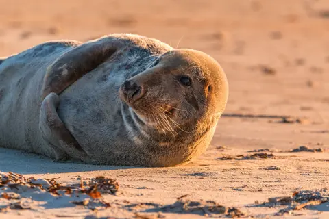
Індіанські острови — це дика, незаселена група на вході до Затоки Кросс в Алясці, відома неймовірними зустрічами з дикою природою, включаючи годування горбатих китів у бульбашковій сітці та величезні колонії морських левів Стеллера. Обов'язкові до виконання досвіди включають екскурсії на Зодіаку вздовж скелястих берегів островів, спостереження за кооперативним годуванням китів та дослідження приливних басейнів, переповнених морським життям. Відвідуйте в липні-серпні для пікового китового активності та найкращих морських умов.
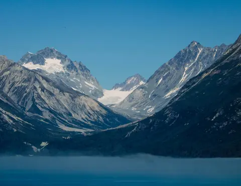
Icy Strait Point — це вражаючий алaskan порт, відомий своєю захоплюючою природною красою та багатою культурою корінних тлінгітів. Обов'язкові до відвідування місця включають насолоду свіжими місцевими морепродуктами та участь у зоологічних екскурсіях у Національному парку Льодовиків. Найкращий сезон для відвідування — влітку, коли погода м'яка, а дика природа в достатку.
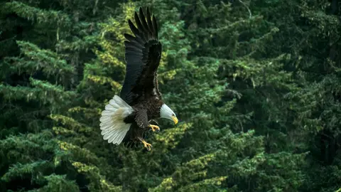
Хейнс — це автентичне містечко Аляски на найглибшому фіорді Північної Америки, де розташована найбільша у світі колонія білих орлів — до чотирьох тисяч птахів уздовж річки Чілкат — та процвітаюча художня спільнота, що зберігає культурні традиції Тлінгіт. Відвідайте з червня по серпень через Cunard або Lindblad для вертольотних посадок на льодовики та прибережних походів, або з жовтня по лютий для надзвичайного видовища орлів, яке робить Хейнс найкращим секретом Аляски.
Lynn Canal is a 90-mile long inlet into Alaska’s coast running from the Chilkat River in the north to the Chatham Strait and Stephens Passage in the south. Because it connects the towns of Skagway and Haines to Juneau and the rest of the Inside Passage, it is an important shipping lane for ferries, cargo and cruise ships, and was a crucial passageway to the Klondike gold fields during the Gold Rush. It was discovered by Joseph Whidbey in 1794 and named by George Vancouver after his birthplace, King’s Lynn in Norfolk, England. More than 2,000 feet in depth, it is one of the deepest and longest fjords in the world, and the deepest in North America outside Greenland.
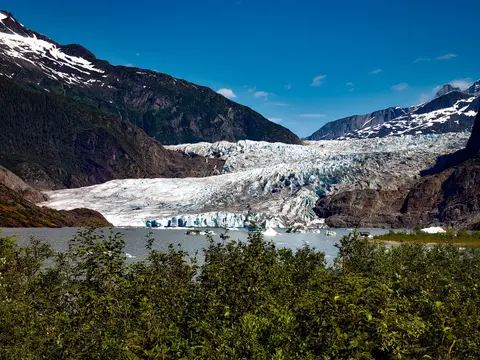
Єдине столичне місто Америки, яке недоступне автомобільним шляхом, Джуно винагороджує подорож величною природою, яку важко зрівняти з будь-яким іншим містом на Землі. Льодовик Менденхолл — живий потік давнього льоду — знаходиться всього за п'ятнадцять хвилин від центру міста, де літаючі човни мчать над набережною, оточеною горами, вкритими ялицями, які стрімко спускаються прямо в море. Обов'язковий досвід — це посадка вертольота на льодовиковому полі або екскурсія для спостереження за китами в проході Стефенса, де горбаті кити вистрибує в приголомшливій близькості. Джуно найтепліший з червня по серпень, хоча навіть літні дні можуть принести відомий дощ Південно-східної Аляски, який підтримує вічно яскравий тропічний ліс.
Day 1
Стиснуте між Тихим океаном і Прибережними горами, Ванкувер є природними воротами до Внутрішнього проходу Аляски — містом, де помірний дощовий ліс зустрічається зі скляними вежами, а краби Дандженес і дикий червоний лосось визначають кухню Тихоокеанського узбережжя, яка може змагатися з будь-якою в Північній Америці. Прогуляйтеся 22-кілометровою набережною Стенлі-парку, загубіться на ринку Гранвілл-Айленд, а потім переправтеся на паром до елегантності Вікторії епохи едуардіанців. Сезон круїзів до Аляски досягає піку з травня по вересень, що робить Ванкувер ідеальною відправною точкою для однієї з великих океанських подорожей світу.
The Seymour Narrows is a 3-mile/5 km stretch of the Discovery Channel north of Vancouver Island, British Columbia that is notorious for the strength of the tidal currents flowing through it. The average width of the narrows is just 750 meters. During extreme tides, the current through the narrows is subject to severe Venturi effect, resulting in an increased velocity that can reach 15 knots. For much of its modern history, there was an additional hazard in the narrows called Ripple Rock, a shallow obstruction that claimed no fewer than 119 ships and 114 lives. In 1958, after months of tunneling and preparation, Ripple Rock was blown up in the largest commercial, non-nuclear explosion ever recorded in North America. Still, the navigation of Seymour Narrows is dependent on tidal and other conditions, and requires skill and technical accomplishment.
Day 2
The Queen Charlotte Sound lies between the Queen Charlotte Strait, which winds between Vancouver Island and the British Columbia mainland in the south, and Hecate Strait, which is northward, adjacent to the Haida Gwaii Islands off the Pacific coast of British Columbia. It is a broad reach in the long shipping route called the Inside Passage threading the myriad islands stretching from Washington’s Puget Sound to Alaska.
Day 3
Кетчікан тримається за лісистий берег острова Ревільягідо в південно-східній частині Аляски — місто таке вузьке, що місцеві жителі жартують, що воно три милі завдовжки і три квартали завширшки. Впродовж тисячоліть його шанували народи Тлінгіт як місце, багате на лосося, а сьогодні його відзначають як Столицю тотемних стовпів світу: колекції в селі корінних народів Саксмана та державному історичному парку Тотем Байт зберігають найбільшу концентрацію цих монументальних витворів мистецтва у світі. Вулиця Крик, пішохідна доріжка кольорових історичних будинків, побудованих над Кетчіканом Крик, не повинна бути пропущена. Літо (травень-вересень) приносить найкращу погоду, з лососем, що пливе в ріках нижче.
In the passage between Sumner Strait and Clarence Strait in Southeast Alaska’s Alexander Archipelago, midway between Price of Wales Island on the west and Zarembo Island on the east, is a small cluster of islands with a picturesque passageway between them called Snow Pass. It makes a scenic up-close route for your Seabourn ship during the transit.
Decision Passage is the western end of the Sumner Strait, which runs through the Alexander Archipelago into the Pacific Ocean in Southeastern Alaska, bounded on the north by Kuiu Island and Cape Decision, the location of a 1932 lighthouse. This is the route your ship takes when coming from or going to the colorful historic community of Sitka on the west coast of Baranof Island, which was originally the Russian fortress town of New Archangel.
Day 4
Сітка, розташована на дикому західному узбережжі острова Бараноф у Південному Алясці, є одним з найісторичніших портів Тихоокеанського Північного Заходу — місцем, де російські православні цибулинні куполи підносяться над тотемними стовпами, а великий помірний тропічний ліс спускається до краю води. Національний історичний парк Сітки зберігає місце битви 1804 року між воїнами Тлінгіт та російськими колонізаторами поряд з чудовою колекцією монументальних стовпів. Спостереження за китами, каякінг серед морських видр та спостереження за бурими ведмедями в навколишній дикій природі визначають досвід на відкритому повітрі. З травня по вересень пропонує найзручніші та найяскравіші умови.
Day 5
Yakutat Bay is 18 miles wide at its entry, and cuts from the Gulf of Alaska into Disenchantment Bay, the entryway to the huge Hubbard Glacier, North America’s largest tidewater glacier. As the bay narrows and the shorelines draw closer, the 400-foot face of the glacier exerts a luminous, ghostly presence, often from as much as 30 miles away. More and more floating ice dimples the surface of the water, and seals bob up and disappear again. The chilled air from the glacier flows in a downdraft of cold that gives rise to mists and gray clouds, through which the vivid blue of the ice wall shimmers. It is an impressive sight of nature’s immense raw workplace, shaping the earth itself as part of an endless cycle of water from the sea evaporating to the sky, falling as snow on the heights and inching over centuries back again to the sea.
The Hubbard Glacier is the largest, and one of the most spectacular tidewater glaciers in North America. Its ice cliffs, some 400’ (121 m) tall, calve icebergs into the fjord, which may frequently be larger than a five-story building. The glacier’s surface is creased and contorted, resembling the wrinkled skin of a giant elephant. Records show it has been growing in thickness and advancing since 1895. This stands in stark contrast to other glaciers around the world, most of which have been receding during the past century. In 2002, the glacier blocked Russell Fjord for two and a half months, raising water levels 61’ (18 m) and threatening local communities with flooding. Nutrient-rich waters along the glacier face attract many species. Gulls and kittiwake colonies adorn smaller islands and harbor seals patrol the icy waters. In 1890, Israel Russell explored the area of Yakutat Bay and Hubbard Glacier, naming it after Gardiner G. Hubbard, a financier of his expedition and a founder and the first president of the National Geographic Society. VIEW CRUISES
Day 6
Індіанські острови — це дика, незаселена група на вході до Затоки Кросс в Алясці, відома неймовірними зустрічами з дикою природою, включаючи годування горбатих китів у бульбашковій сітці та величезні колонії морських левів Стеллера. Обов'язкові до виконання досвіди включають екскурсії на Зодіаку вздовж скелястих берегів островів, спостереження за кооперативним годуванням китів та дослідження приливних басейнів, переповнених морським життям. Відвідуйте в липні-серпні для пікового китового активності та найкращих морських умов.
Icy Strait Point — це вражаючий алaskan порт, відомий своєю захоплюючою природною красою та багатою культурою корінних тлінгітів. Обов'язкові до відвідування місця включають насолоду свіжими місцевими морепродуктами та участь у зоологічних екскурсіях у Національному парку Льодовиків. Найкращий сезон для відвідування — влітку, коли погода м'яка, а дика природа в достатку.
Day 7
Хейнс — це автентичне містечко Аляски на найглибшому фіорді Північної Америки, де розташована найбільша у світі колонія білих орлів — до чотирьох тисяч птахів уздовж річки Чілкат — та процвітаюча художня спільнота, що зберігає культурні традиції Тлінгіт. Відвідайте з червня по серпень через Cunard або Lindblad для вертольотних посадок на льодовики та прибережних походів, або з жовтня по лютий для надзвичайного видовища орлів, яке робить Хейнс найкращим секретом Аляски.
Lynn Canal is a 90-mile long inlet into Alaska’s coast running from the Chilkat River in the north to the Chatham Strait and Stephens Passage in the south. Because it connects the towns of Skagway and Haines to Juneau and the rest of the Inside Passage, it is an important shipping lane for ferries, cargo and cruise ships, and was a crucial passageway to the Klondike gold fields during the Gold Rush. It was discovered by Joseph Whidbey in 1794 and named by George Vancouver after his birthplace, King’s Lynn in Norfolk, England. More than 2,000 feet in depth, it is one of the deepest and longest fjords in the world, and the deepest in North America outside Greenland.
Day 8
Єдине столичне місто Америки, яке недоступне автомобільним шляхом, Джуно винагороджує подорож величною природою, яку важко зрівняти з будь-яким іншим містом на Землі. Льодовик Менденхолл — живий потік давнього льоду — знаходиться всього за п'ятнадцять хвилин від центру міста, де літаючі човни мчать над набережною, оточеною горами, вкритими ялицями, які стрімко спускаються прямо в море. Обов'язковий досвід — це посадка вертольота на льодовиковому полі або екскурсія для спостереження за китами в проході Стефенса, де горбаті кити вистрибує в приголомшливій близькості. Джуно найтепліший з червня по серпень, хоча навіть літні дні можуть принести відомий дощ Південно-східної Аляски, який підтримує вічно яскравий тропічний ліс.









Our cruise specialists can help you find the perfect cabin and the best available pricing.
(+886) 02-2721-7300Contact Advisor