تاریخ
2026-08-07
مدت
14 شب
بندر مبدأ
ونکوور
کانادا
بندر مقصد
ونکوور
کانادا
رده
لوکس
موضوع
—
تاریخ
2026-08-07
مدت
14 شب
بندر مبدأ
ونکوور
کانادا
بندر مقصد
ونکوور
کانادا
رده
لوکس
موضوع
—


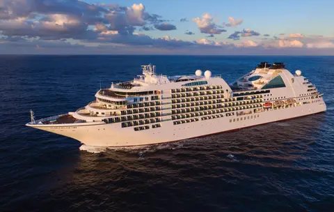
سیبورن
2016
—
40,350 GT
600
266
330
690 m
28 m
19 knots
خیر

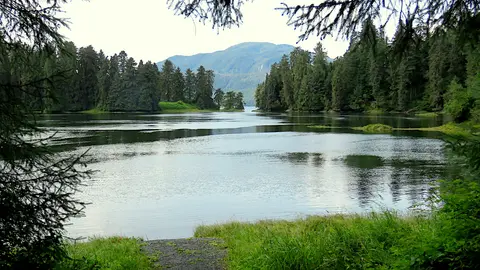
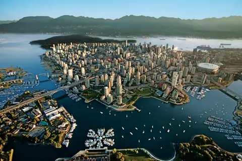
فشرده بین اقیانوس آرام و کوههای ساحلی، ونکوور دروازه طبیعی به مسیر داخلی آلاسکا است — شهری که جنگل بارانی معتدل با برجهای شیشهای ملاقات میکند و جلبک دریایی و سالمون وحشی دنجنس را به یک آشپزی اقیانوس آرام تبدیل میکند که با هر کدام در آمریکای شمالی رقابت میکند. بر روی دیواره ساحلی پارک استنلی به طول ۲۲ کیلومتر قدم بزنید، در بازار جزیره گرانویل گم شوید و سپس با قایق به شکوه ادواردی ویکتوریا بروید. فصل کروز آلاسکا از مه تا سپتامبر به اوج خود میرسد و ونکوور را به نقطه شروع ایدهآل برای یکی از بزرگترین سفرهای دریایی جهان تبدیل میکند.
The Queen Charlotte Sound lies between the Queen Charlotte Strait, which winds between Vancouver Island and the British Columbia mainland in the south, and Hecate Strait, which is northward, adjacent to the Haida Gwaii Islands off the Pacific coast of British Columbia. It is a broad reach in the long shipping route called the Inside Passage threading the myriad islands stretching from Washington’s Puget Sound to Alaska.
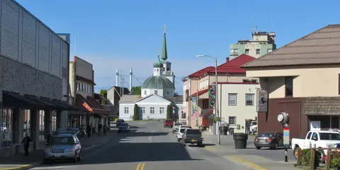
کچیکان به ساحل جنگلی جزیره ریویلاگیگدو در نوار جنوب شرقی آلاسکا چسبیده است — شهری که آنقدر باریک است که محلیها شوخی میکنند که سه مایل طول و سه بلوک عرض دارد. این مکان از هزاران سال پیش توسط مردم تِلینگیت به عنوان مکانی با ماهی سالمون فراوان مورد احترام بوده و امروزه به عنوان پایتخت تندیسهای توتم در جهان شناخته میشود: مجموعههای موجود در روستای بومی ساکسمن و پارک تاریخی ایالتی توتم بایت، بیشترین غلظت این آثار هنری عظیم را در هر جایی حفظ کردهاند. خیابان کریک، یک پیادهروی از خانههای تاریخی رنگارنگ که بر روی کریک کچیکان ساخته شدهاند، نباید از دست برود. تابستان (مه تا سپتامبر) بهترین آب و هوا را به ارمغان میآورد، با ماهی سالمون در جویبارهای زیر.
In the passage between Sumner Strait and Clarence Strait in Southeast Alaska’s Alexander Archipelago, midway between Price of Wales Island on the west and Zarembo Island on the east, is a small cluster of islands with a picturesque passageway between them called Snow Pass. It makes a scenic up-close route for your Seabourn ship during the transit.
سیتکا، واقع در سواحل وحشی جزیره بارانوف در جنوب شرقی آلاسکا، یکی از بندرهای تاریخیترین شمال غرب اقیانوس آرام است — جایی که گنبدهای پیاز روسی ارتدکس بالای تندیسهای توتم قرار دارند و جنگل بارانی بزرگ معتدل به لبه آب فشار میآورد. پارک تاریخی ملی سیتکا محل نبرد 1804 بین جنگجویان تلینگیت و استعمارگران روسی را در کنار مجموعهای باشکوه از تیرکهای یادبود حفظ میکند. تماشای نهنگ، کایاکسواری در میان سمورهای دریایی و مشاهده خرسهای قهوهای در حیات وحش اطراف، تجربهای در فضای باز را تعریف میکند. از مه تا سپتامبر شرایط قابل دسترستر و درخشانترین را ارائه میدهد.
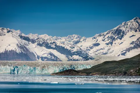
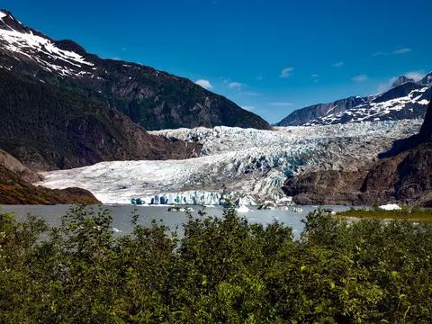
یخچال هابارد، که به عنوان "یخچال در حال دویدن" شناخته میشود، یک شگفتی طبیعی خیرهکننده در شرق آلاسکا است که بازدیدکنندگان را با شکلهای یخی خیرهکننده و حیات وحش خود مجذوب میکند. تجربیات ضروری شامل تماشای ریزش یخچال و چشیدن غذاهای محلی مانند خرچنگ دانجن و سوسیس گوزن در اسکاگوی نزدیک است. بهترین فصل برای بازدید در ماههای تابستان است که هوا ملایمتر و حیات وحش فراوانتر است.
The Hubbard Glacier is the largest, and one of the most spectacular tidewater glaciers in North America. Its ice cliffs, some 400’ (121 m) tall, calve icebergs into the fjord, which may frequently be larger than a five-story building. The glacier’s surface is creased and contorted, resembling the wrinkled skin of a giant elephant. Records show it has been growing in thickness and advancing since 1895. This stands in stark contrast to other glaciers around the world, most of which have been receding during the past century. In 2002, the glacier blocked Russell Fjord for two and a half months, raising water levels 61’ (18 m) and threatening local communities with flooding. Nutrient-rich waters along the glacier face attract many species. Gulls and kittiwake colonies adorn smaller islands and harbor seals patrol the icy waters. In 1890, Israel Russell explored the area of Yakutat Bay and Hubbard Glacier, naming it after Gardiner G. Hubbard, a financier of his expedition and a founder and the first president of the National Geographic Society. VIEW CRUISES
جزایر اینیان یک خوشه وحشی و غیرمسکونی در ورودی صدای کراس آلاسکا هستند که به خاطر برخوردهای فوقالعاده با حیات وحش شامل تغذیه نهنگهای گوژپشت با حباب و کلونیهای بزرگ شیر دریایی استلر مشهورند. کارهای ضروری شامل گشت و گذار با زودیاک در سواحل سنگی جزایر، تماشای تغذیه همکاری نهنگها و کاوش در حوضچههای جزر و مدی پر از زندگی دریایی است. از ژوئیه تا اوت برای فعالیت نهنگها در اوج و بهترین شرایط دریا بازدید کنید.
هینس یک شهر اصیل آلاسکایی در عمیقترین فیورد آمریکای شمالی است، که خانه بزرگترین تجمع عقابهای طاس جهان — تا چهار هزار پرنده در طول رودخانه چیلتک — و یک جامعه هنری پررونق است که سنتهای فرهنگی تِلینگیت را حفظ میکند. از ژوئن تا اوت از طریق کونا رد یا لیندبلاد برای فرود هلیکوپتر بر روی یخچالهای طبیعی و پیادهرویهای ساحلی دیدن کنید، یا از اکتبر تا فوریه برای تماشای نمایش فوقالعاده عقابها که هینس را به بهترین راز نگهداری شده آلاسکا تبدیل کرده است.
تنها پایتخت ایالت آمریکا که از طریق جاده قابل دسترسی نیست، جونو سفر را با عظمت وحشیانهای پاداش میدهد که کمتر شهری در زمین میتواند با آن رقابت کند. یخچال طبیعی مندنهال — یک رودخانه زنده از یخ باستانی — تنها پانزده دقیقه از مرکز شهر فاصله دارد، جایی که هواپیماهای شناور در بالای یک نوار آبی که با کوههای پوشیده از درختان کاج احاطه شده است، پرواز میکنند. تجربه ضروری، فرود هلیکوپتر بر روی میدان یخی یا یک گشت تماشای نهنگ در گذرگاه استیفن است، جایی که نهنگهای گوژپشت در نزدیکی شگفتانگیز پرش میکنند. جونو از ژوئن تا اوت گرمترین است، اگرچه حتی روزهای تابستان میتوانند باران معروف آلاسکای جنوب شرقی را به ارمغان بیاورند که جنگلهای بارانی را به طور دائمی درخشان نگه میدارد.
آرْم تریسی یک fjord خیرهکننده ۳۰ مایلی در جنگل ملی تنگاس آلاسکا است که به خاطر مناظر دراماتیک و حیات وحش فراوانش شناخته شده است. تجربیات ضروری شامل کروز در fjord برای مشاهده یخچالهای یخزده و لذت بردن از غذاهای دریایی محلی مانند ماهی قزلآلای دودی است. بهترین فصل برای بازدید در ماههای تابستان است که منطقه زنده و قابل دسترسی است.
ورانگل یکی از واقعیترین بندرهای مسیر داخلی آلاسکا است، جایی که میراث تلینگیت، پتروگلیفهای باستانی و حیات وحش جهانی در دهانه رودخانه قدرتمند استیکین گرد هم میآیند. تجربیات ضروری شامل قایقسواری جت به یخچال طبیعی لکانته، تماشای خرسها در حال ماهیگیری در رودخانه آنان و چشیدن ماهی سالمون دودی محلی است. ماههای ژوئیه و اوت بهترین زمان برای مشاهده ماهیگیری سالمون و خرسها هستند.
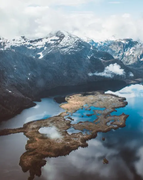
یادبود ملی میستی فیوردز یک wilderness به مساحت ۹۳۰,۰۰۰ هکتار در جنوب شرقی آلاسکا است، جایی که صخرههای گرانیتی صاف از فیوردهای آرام و در میان پردههای دائمی مه و ابر برمیخیزند. از جمله کارهایی که باید انجام دهید، کایاکسواری در بازوهای ساکت فیورد، قایقسواری زودیاک در کنار آبشارها و سنگ آتشفشانی نیو اددستون و تماشای خرسها، عقابها و اورکاها در کانالهای بکر است. از ماه مه تا سپتامبر فصل بازدید است، با باران که به جو اترال یادبود افزوده میشود.
پرنس روپر، یک پایانه تاریخی راهآهن در سواحل شمالی بریتیش کلمبیا، بازدیدکنندگان را با میراث عمیق تسیمشین، ماهیگیری هالیبوت با کیفیت جهانی و مناظر جنگل بارانی مهآلود در طول گذرگاه داخلی مجذوب میکند. ماهی سالمون دودی تازه را در کنار آب sampled کنید و به کاوش در کارخانه کنسرو شمال اقیانوس آرام بپردازید، قدیمیترین کارخانه کنسرو باقیمانده کانادا، برای تجربهای زنده از روح دریایی بندر. بهترین زمان برای بازدید از ژوئن تا اوت است، زمانی که روزهای طولانی بارش معروف را تعدیل میکند و فعالیت حیات وحش در سواحل به اوج خود میرسد.
Grenville Channel is a long, well-protected channel along the northern British Columbia coast between the large Pitt Island and the mainland. It is an important shipping lane, and you are likely to see ships of many different types and sizes as you pass through. The shores are mountainous on both sides, with two notable peaks about halfway through, Mt. Batchellor on the east side and Mt. Saunders on Pitt Island to the west. There are a number of Indian Reserves and Marine Parks in the mountains and narrow waterways off the channel.
Whale Channel is a picturesque waterway separating Gil Island from Princess Royal Island in British Columbia’s Inside Passage. Surrounded by snow-capped mountain ranges and teeming with marine life, It is a diversion from the main shipping lane, located roughly halfway between Prince Rupert and the First Nations village of Klemtu. VIEW CRUISES Skip Footer Content About Us
The Princess Royal Channel separates the largest island along British Columbia’s coast from the mainland. It is located roughly halfway between Bella Bella in the south and Prince Rupert in the north, in one of the province’s most remote areas. Princess Royal island was named in 1788 by Captain Charles Duncan, in honor of his ship, the Princess Royal. The island is uninhabited, although there are two small villages in the channel, the First Nations community of Klemtu on Swindle Island and Hartley Bay on the mainland. Wildlife, by contrast, is plentiful, including Kermode, black and grizzly bears, deer, wolves and foxes. Golden and bald eagles nest in the region, as well as the endangered marbled murrelet. In the waters, there are abundant salmon, elephant seals, whales, orcas and dolphins.
بندر آلارم، کانادا یک شهر بندری متمایز است که در آن میراث فرهنگی عمیق با جو محلی اصیل تلاقی میکند و در برنامههای سفر HX Expeditions گنجانده شده است. تجربیات ضروری شامل پیادهروی در مرکز تاریخی برای تجربه میراث معماری لایهلایه و جستجوی سنتهای آشپزی منطقهای در یک مکان محلی محبوب دور از ناحیه بندر است. بهترین زمان برای بازدید از ژوئن تا اوت است، زمانی که ماههای تابستان گرمترین دماها و طولانیترین روزها را به ارمغان میآورد.
Johnstone Strait is a well-protected shipping route passing 68 miles/110 km along the northeast shore of Vancouver Island between the island and the mainland of British Columbia. The strait is between 1 ½ miles and 3 miles wide, and leads from the broad Georgia Strait through a narrow channel called Discovery Passage. The strait was named by Vancouver in 1792 for James Johnstone, the master of one of his tenders during the survey expedition that revealed Vancouver Island to be an island. There are no cities or towns on the strait. The Johnstone Strait is the summer range of a large pod of seasonally resident orcas which are frequently seen in the area. VIEW CRUISES Skip Footer Content About Us Our Company News Careers Contact Us Video Gallery Accessibility Seabourn Club Seabourn Referral Program Travel Resources
فشرده بین اقیانوس آرام و کوههای ساحلی، ونکوور دروازه طبیعی به مسیر داخلی آلاسکا است — شهری که جنگل بارانی معتدل با برجهای شیشهای ملاقات میکند و جلبک دریایی و سالمون وحشی دنجنس را به یک آشپزی اقیانوس آرام تبدیل میکند که با هر کدام در آمریکای شمالی رقابت میکند. بر روی دیواره ساحلی پارک استنلی به طول ۲۲ کیلومتر قدم بزنید، در بازار جزیره گرانویل گم شوید و سپس با قایق به شکوه ادواردی ویکتوریا بروید. فصل کروز آلاسکا از مه تا سپتامبر به اوج خود میرسد و ونکوور را به نقطه شروع ایدهآل برای یکی از بزرگترین سفرهای دریایی جهان تبدیل میکند.
روز 1
فشرده بین اقیانوس آرام و کوههای ساحلی، ونکوور دروازه طبیعی به مسیر داخلی آلاسکا است — شهری که جنگل بارانی معتدل با برجهای شیشهای ملاقات میکند و جلبک دریایی و سالمون وحشی دنجنس را به یک آشپزی اقیانوس آرام تبدیل میکند که با هر کدام در آمریکای شمالی رقابت میکند. بر روی دیواره ساحلی پارک استنلی به طول ۲۲ کیلومتر قدم بزنید، در بازار جزیره گرانویل گم شوید و سپس با قایق به شکوه ادواردی ویکتوریا بروید. فصل کروز آلاسکا از مه تا سپتامبر به اوج خود میرسد و ونکوور را به نقطه شروع ایدهآل برای یکی از بزرگترین سفرهای دریایی جهان تبدیل میکند.
روز 2
The Queen Charlotte Sound lies between the Queen Charlotte Strait, which winds between Vancouver Island and the British Columbia mainland in the south, and Hecate Strait, which is northward, adjacent to the Haida Gwaii Islands off the Pacific coast of British Columbia. It is a broad reach in the long shipping route called the Inside Passage threading the myriad islands stretching from Washington’s Puget Sound to Alaska.
روز 3
کچیکان به ساحل جنگلی جزیره ریویلاگیگدو در نوار جنوب شرقی آلاسکا چسبیده است — شهری که آنقدر باریک است که محلیها شوخی میکنند که سه مایل طول و سه بلوک عرض دارد. این مکان از هزاران سال پیش توسط مردم تِلینگیت به عنوان مکانی با ماهی سالمون فراوان مورد احترام بوده و امروزه به عنوان پایتخت تندیسهای توتم در جهان شناخته میشود: مجموعههای موجود در روستای بومی ساکسمن و پارک تاریخی ایالتی توتم بایت، بیشترین غلظت این آثار هنری عظیم را در هر جایی حفظ کردهاند. خیابان کریک، یک پیادهروی از خانههای تاریخی رنگارنگ که بر روی کریک کچیکان ساخته شدهاند، نباید از دست برود. تابستان (مه تا سپتامبر) بهترین آب و هوا را به ارمغان میآورد، با ماهی سالمون در جویبارهای زیر.
In the passage between Sumner Strait and Clarence Strait in Southeast Alaska’s Alexander Archipelago, midway between Price of Wales Island on the west and Zarembo Island on the east, is a small cluster of islands with a picturesque passageway between them called Snow Pass. It makes a scenic up-close route for your Seabourn ship during the transit.
روز 4
سیتکا، واقع در سواحل وحشی جزیره بارانوف در جنوب شرقی آلاسکا، یکی از بندرهای تاریخیترین شمال غرب اقیانوس آرام است — جایی که گنبدهای پیاز روسی ارتدکس بالای تندیسهای توتم قرار دارند و جنگل بارانی بزرگ معتدل به لبه آب فشار میآورد. پارک تاریخی ملی سیتکا محل نبرد 1804 بین جنگجویان تلینگیت و استعمارگران روسی را در کنار مجموعهای باشکوه از تیرکهای یادبود حفظ میکند. تماشای نهنگ، کایاکسواری در میان سمورهای دریایی و مشاهده خرسهای قهوهای در حیات وحش اطراف، تجربهای در فضای باز را تعریف میکند. از مه تا سپتامبر شرایط قابل دسترستر و درخشانترین را ارائه میدهد.
روز 5
یخچال هابارد، که به عنوان "یخچال در حال دویدن" شناخته میشود، یک شگفتی طبیعی خیرهکننده در شرق آلاسکا است که بازدیدکنندگان را با شکلهای یخی خیرهکننده و حیات وحش خود مجذوب میکند. تجربیات ضروری شامل تماشای ریزش یخچال و چشیدن غذاهای محلی مانند خرچنگ دانجن و سوسیس گوزن در اسکاگوی نزدیک است. بهترین فصل برای بازدید در ماههای تابستان است که هوا ملایمتر و حیات وحش فراوانتر است.
The Hubbard Glacier is the largest, and one of the most spectacular tidewater glaciers in North America. Its ice cliffs, some 400’ (121 m) tall, calve icebergs into the fjord, which may frequently be larger than a five-story building. The glacier’s surface is creased and contorted, resembling the wrinkled skin of a giant elephant. Records show it has been growing in thickness and advancing since 1895. This stands in stark contrast to other glaciers around the world, most of which have been receding during the past century. In 2002, the glacier blocked Russell Fjord for two and a half months, raising water levels 61’ (18 m) and threatening local communities with flooding. Nutrient-rich waters along the glacier face attract many species. Gulls and kittiwake colonies adorn smaller islands and harbor seals patrol the icy waters. In 1890, Israel Russell explored the area of Yakutat Bay and Hubbard Glacier, naming it after Gardiner G. Hubbard, a financier of his expedition and a founder and the first president of the National Geographic Society. VIEW CRUISES
روز 6
جزایر اینیان یک خوشه وحشی و غیرمسکونی در ورودی صدای کراس آلاسکا هستند که به خاطر برخوردهای فوقالعاده با حیات وحش شامل تغذیه نهنگهای گوژپشت با حباب و کلونیهای بزرگ شیر دریایی استلر مشهورند. کارهای ضروری شامل گشت و گذار با زودیاک در سواحل سنگی جزایر، تماشای تغذیه همکاری نهنگها و کاوش در حوضچههای جزر و مدی پر از زندگی دریایی است. از ژوئیه تا اوت برای فعالیت نهنگها در اوج و بهترین شرایط دریا بازدید کنید.
روز 7
هینس یک شهر اصیل آلاسکایی در عمیقترین فیورد آمریکای شمالی است، که خانه بزرگترین تجمع عقابهای طاس جهان — تا چهار هزار پرنده در طول رودخانه چیلتک — و یک جامعه هنری پررونق است که سنتهای فرهنگی تِلینگیت را حفظ میکند. از ژوئن تا اوت از طریق کونا رد یا لیندبلاد برای فرود هلیکوپتر بر روی یخچالهای طبیعی و پیادهرویهای ساحلی دیدن کنید، یا از اکتبر تا فوریه برای تماشای نمایش فوقالعاده عقابها که هینس را به بهترین راز نگهداری شده آلاسکا تبدیل کرده است.
روز 8
تنها پایتخت ایالت آمریکا که از طریق جاده قابل دسترسی نیست، جونو سفر را با عظمت وحشیانهای پاداش میدهد که کمتر شهری در زمین میتواند با آن رقابت کند. یخچال طبیعی مندنهال — یک رودخانه زنده از یخ باستانی — تنها پانزده دقیقه از مرکز شهر فاصله دارد، جایی که هواپیماهای شناور در بالای یک نوار آبی که با کوههای پوشیده از درختان کاج احاطه شده است، پرواز میکنند. تجربه ضروری، فرود هلیکوپتر بر روی میدان یخی یا یک گشت تماشای نهنگ در گذرگاه استیفن است، جایی که نهنگهای گوژپشت در نزدیکی شگفتانگیز پرش میکنند. جونو از ژوئن تا اوت گرمترین است، اگرچه حتی روزهای تابستان میتوانند باران معروف آلاسکای جنوب شرقی را به ارمغان بیاورند که جنگلهای بارانی را به طور دائمی درخشان نگه میدارد.
روز 9
آرْم تریسی یک fjord خیرهکننده ۳۰ مایلی در جنگل ملی تنگاس آلاسکا است که به خاطر مناظر دراماتیک و حیات وحش فراوانش شناخته شده است. تجربیات ضروری شامل کروز در fjord برای مشاهده یخچالهای یخزده و لذت بردن از غذاهای دریایی محلی مانند ماهی قزلآلای دودی است. بهترین فصل برای بازدید در ماههای تابستان است که منطقه زنده و قابل دسترسی است.
روز 10
ورانگل یکی از واقعیترین بندرهای مسیر داخلی آلاسکا است، جایی که میراث تلینگیت، پتروگلیفهای باستانی و حیات وحش جهانی در دهانه رودخانه قدرتمند استیکین گرد هم میآیند. تجربیات ضروری شامل قایقسواری جت به یخچال طبیعی لکانته، تماشای خرسها در حال ماهیگیری در رودخانه آنان و چشیدن ماهی سالمون دودی محلی است. ماههای ژوئیه و اوت بهترین زمان برای مشاهده ماهیگیری سالمون و خرسها هستند.
روز 11
یادبود ملی میستی فیوردز یک wilderness به مساحت ۹۳۰,۰۰۰ هکتار در جنوب شرقی آلاسکا است، جایی که صخرههای گرانیتی صاف از فیوردهای آرام و در میان پردههای دائمی مه و ابر برمیخیزند. از جمله کارهایی که باید انجام دهید، کایاکسواری در بازوهای ساکت فیورد، قایقسواری زودیاک در کنار آبشارها و سنگ آتشفشانی نیو اددستون و تماشای خرسها، عقابها و اورکاها در کانالهای بکر است. از ماه مه تا سپتامبر فصل بازدید است، با باران که به جو اترال یادبود افزوده میشود.
روز 12
پرنس روپر، یک پایانه تاریخی راهآهن در سواحل شمالی بریتیش کلمبیا، بازدیدکنندگان را با میراث عمیق تسیمشین، ماهیگیری هالیبوت با کیفیت جهانی و مناظر جنگل بارانی مهآلود در طول گذرگاه داخلی مجذوب میکند. ماهی سالمون دودی تازه را در کنار آب sampled کنید و به کاوش در کارخانه کنسرو شمال اقیانوس آرام بپردازید، قدیمیترین کارخانه کنسرو باقیمانده کانادا، برای تجربهای زنده از روح دریایی بندر. بهترین زمان برای بازدید از ژوئن تا اوت است، زمانی که روزهای طولانی بارش معروف را تعدیل میکند و فعالیت حیات وحش در سواحل به اوج خود میرسد.
روز 13
Grenville Channel is a long, well-protected channel along the northern British Columbia coast between the large Pitt Island and the mainland. It is an important shipping lane, and you are likely to see ships of many different types and sizes as you pass through. The shores are mountainous on both sides, with two notable peaks about halfway through, Mt. Batchellor on the east side and Mt. Saunders on Pitt Island to the west. There are a number of Indian Reserves and Marine Parks in the mountains and narrow waterways off the channel.
Whale Channel is a picturesque waterway separating Gil Island from Princess Royal Island in British Columbia’s Inside Passage. Surrounded by snow-capped mountain ranges and teeming with marine life, It is a diversion from the main shipping lane, located roughly halfway between Prince Rupert and the First Nations village of Klemtu. VIEW CRUISES Skip Footer Content About Us
The Princess Royal Channel separates the largest island along British Columbia’s coast from the mainland. It is located roughly halfway between Bella Bella in the south and Prince Rupert in the north, in one of the province’s most remote areas. Princess Royal island was named in 1788 by Captain Charles Duncan, in honor of his ship, the Princess Royal. The island is uninhabited, although there are two small villages in the channel, the First Nations community of Klemtu on Swindle Island and Hartley Bay on the mainland. Wildlife, by contrast, is plentiful, including Kermode, black and grizzly bears, deer, wolves and foxes. Golden and bald eagles nest in the region, as well as the endangered marbled murrelet. In the waters, there are abundant salmon, elephant seals, whales, orcas and dolphins.
روز 14
بندر آلارم، کانادا یک شهر بندری متمایز است که در آن میراث فرهنگی عمیق با جو محلی اصیل تلاقی میکند و در برنامههای سفر HX Expeditions گنجانده شده است. تجربیات ضروری شامل پیادهروی در مرکز تاریخی برای تجربه میراث معماری لایهلایه و جستجوی سنتهای آشپزی منطقهای در یک مکان محلی محبوب دور از ناحیه بندر است. بهترین زمان برای بازدید از ژوئن تا اوت است، زمانی که ماههای تابستان گرمترین دماها و طولانیترین روزها را به ارمغان میآورد.
Johnstone Strait is a well-protected shipping route passing 68 miles/110 km along the northeast shore of Vancouver Island between the island and the mainland of British Columbia. The strait is between 1 ½ miles and 3 miles wide, and leads from the broad Georgia Strait through a narrow channel called Discovery Passage. The strait was named by Vancouver in 1792 for James Johnstone, the master of one of his tenders during the survey expedition that revealed Vancouver Island to be an island. There are no cities or towns on the strait. The Johnstone Strait is the summer range of a large pod of seasonally resident orcas which are frequently seen in the area. VIEW CRUISES Skip Footer Content About Us Our Company News Careers Contact Us Video Gallery Accessibility Seabourn Club Seabourn Referral Program Travel Resources
روز 15
فشرده بین اقیانوس آرام و کوههای ساحلی، ونکوور دروازه طبیعی به مسیر داخلی آلاسکا است — شهری که جنگل بارانی معتدل با برجهای شیشهای ملاقات میکند و جلبک دریایی و سالمون وحشی دنجنس را به یک آشپزی اقیانوس آرام تبدیل میکند که با هر کدام در آمریکای شمالی رقابت میکند. بر روی دیواره ساحلی پارک استنلی به طول ۲۲ کیلومتر قدم بزنید، در بازار جزیره گرانویل گم شوید و سپس با قایق به شکوه ادواردی ویکتوریا بروید. فصل کروز آلاسکا از مه تا سپتامبر به اوج خود میرسد و ونکوور را به نقطه شروع ایدهآل برای یکی از بزرگترین سفرهای دریایی جهان تبدیل میکند.


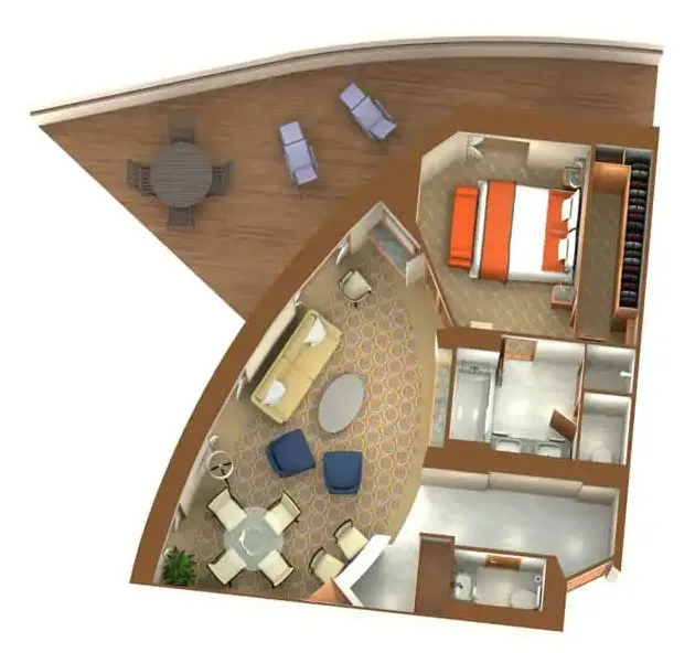
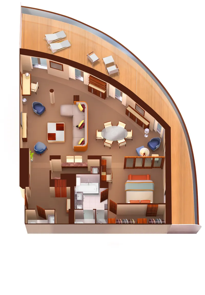
Grand Wintergarden Suite
واقع در عرشه 8؛ میتوانید سوئیتهای میانه 849 و 851 را برای ایجاد سوئیت 8491 یا سوئیتهای 846 و 848 را برای ایجاد سوئیت 8468 ترکیب کنید که فضای داخلی کل 1,292 فوت مربع (120 متر مربع) به علاوه دو تراس با مساحت کل 244 فوت مربع (23 متر مربع) دارد.
سوئیتهای Grand Wintergarden شامل:
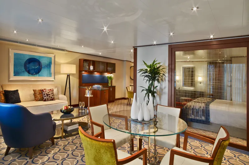

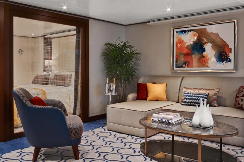
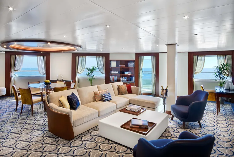
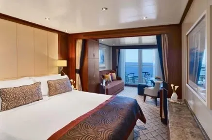
Owners Suite
سوئیتهای مالک در عرشههای 7، 8، 9 و 10 واقع شدهاند؛ فضای داخلی کل بین 576 تا 597 فوت مربع (54 تا 55 متر مربع) به علاوه بالکن بین 142 تا 778 فوت مربع (13 تا 72 متر مربع).
سوئیتهای مالک شامل:

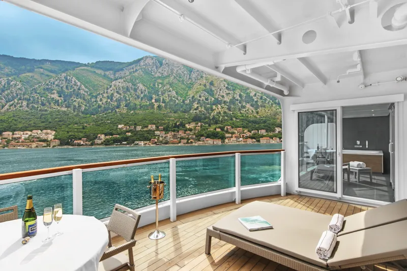
Penthouse Spa Suite
سوئیت اسپای پنت هاوس
واقع در عرشه 11؛ فضای داخلی کل بین 639 تا 677 فوت مربع (59 تا 63 متر مربع) به علاوه بالکن بین 254 تا 288 فوت مربع (24 تا 27 متر مربع)
تمام سوئیتهای اسپای پنت هاوس شامل
میز ناهارخوری برای دو تا چهار نفر
اتاق خواب جداگانه
در شیشهای به بالکن
دو تلویزیون صفحهتخت
بار کاملاً مجهز
حمام جادار با وان، دوش و میز آرایش بزرگ

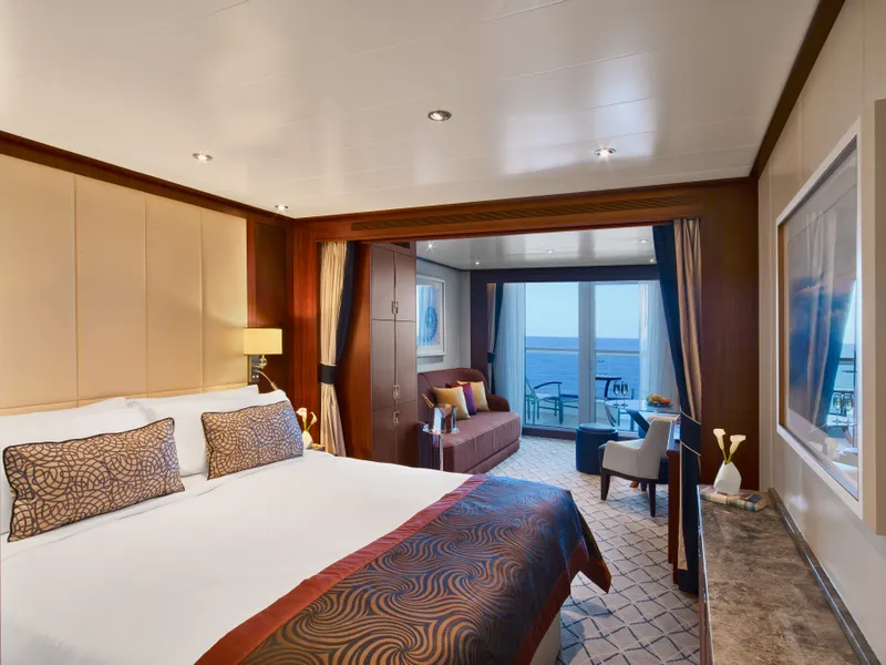
Penthouse Suite
سوئیتهای پنتهاوس در عرشههای 10 و 11 واقع شدهاند؛ فضای داخلی کل بین 449 تا 450 فوت مربع (42 متر مربع) به علاوه یک بالکن بین 93 تا 103 فوت مربع (9 و 10 متر مربع).
تمام سوئیتهای پنتهاوس شامل:
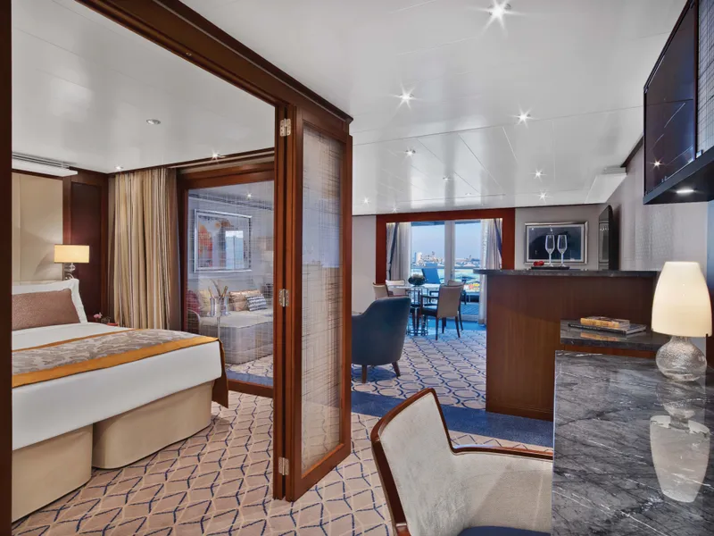
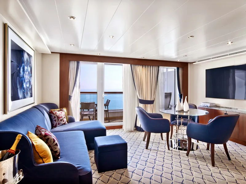
Signature Suite
در عرشه 8 واقع شده است؛ سوئیتهای جلو 800 و 801 با فضای داخلی تقریباً 977 فوت مربع (90 متر مربع)، به علاوه یک بالکن به مساحت 960 فوت مربع (89 متر مربع).
سوئیتهای امضا شامل:


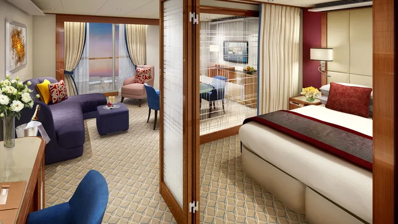
Wintergarden Suite
واقع در عرشه 8؛ سوئیتهای میانه کشتی 846 و 849 با فضای داخلی 989 فوت مربع (92 متر مربع) به علاوه یک بالکن 197 فوت مربع (18 متر مربع).
سوئیتهای Wintergarden شامل:
Single Veranda Suite Guarantee
سوئیت یک نفره با بالکن تضمینی


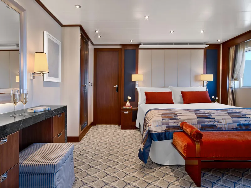
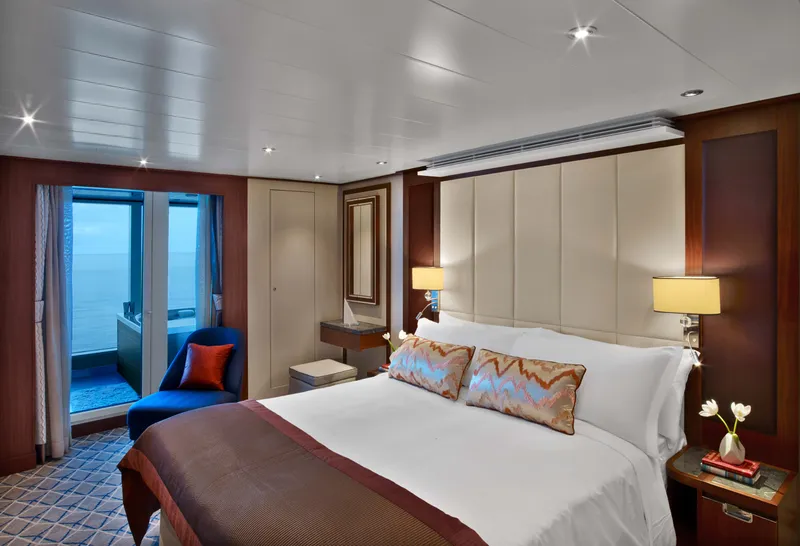
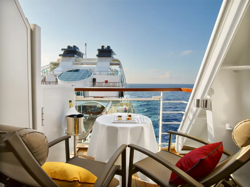
Veranda Suite
سوئیتهای دارای بالکن در عرشههای 8، 9، 10 و 11 قرار دارند؛ فضای داخلی کل بین 246 تا 302 فوت مربع (23 تا 28 متر مربع) به علاوه یک بالکن بین 68 تا 83 فوت مربع (6 تا 7 متر مربع).
تمام سوئیتهای دارای بالکن شامل:


Veranda Suite Guarantee
سوئیت بالکن تضمینی
متخصصان ما به شما کمک میکنند تا کابین مناسب را با بهترین قیمت پیدا کنید.
(+886) 02-2721-7300تماس با مشاور