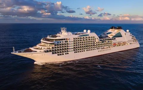
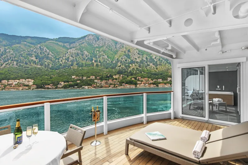
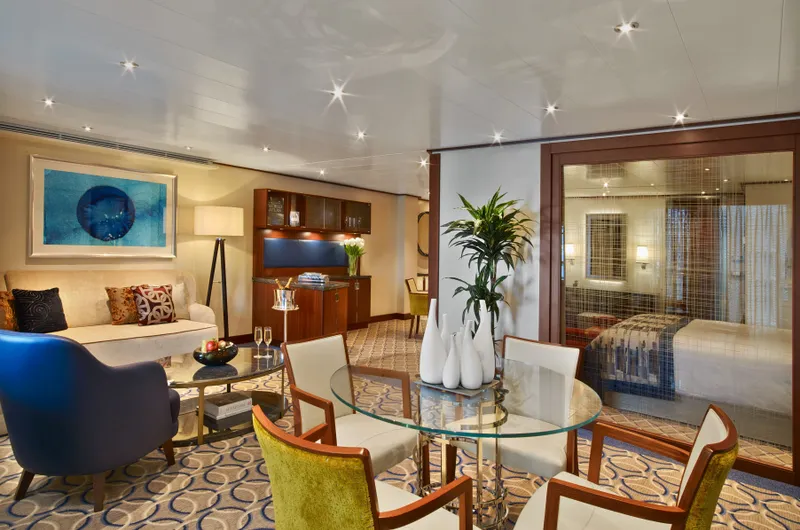
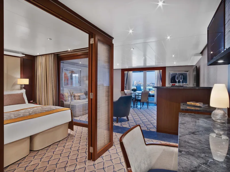
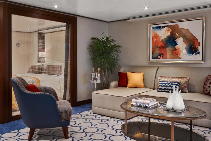
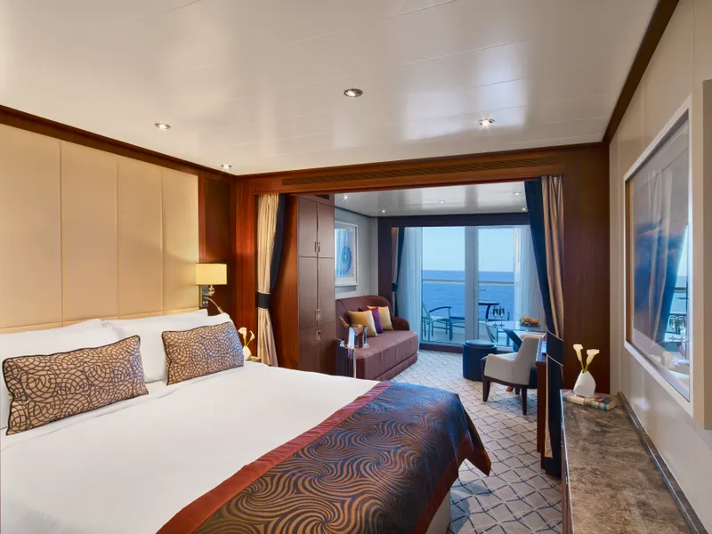
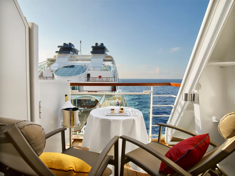
Seabourn7654A
Alaska Gletsjers, Fjorden & Binnenpassage
Date
2026-08-07
Duration
14 nights
Departure Port
Vancouver
Canada
Arrival Port
Vancouver
Canada
Rating
Luxury
Theme
—
Date
2026-08-07
Duration
14 nights
Departure Port
Vancouver
Canada
Arrival Port
Vancouver
Canada
Rating
Luxury
Theme
—


Seabourn
2016
—
40,350 GT
600
266
330
690 m
28 m
19 knots
No

Geperst tussen de Stille Oceaan en de Coast Mountains, is Vancouver de natuurlijke toegangspoort tot de Inside Passage van Alaska — een stad waar gematigd regenwoud ontmoet glazen torens en waar Dungeness-kreeft en wilde sockeye-zalm een Pacific Rim-keuken definiëren die met elke in Noord-Amerika kan concurreren. Wandel over de 22 kilometer lange zeewering van Stanley Park, verdwaal in de markt van Granville Island en neem de veerboot naar de Edwardiaanse pracht van Victoria. Het cruiseseizoen naar Alaska bereikt zijn hoogtepunt van mei tot september, waardoor Vancouver een ideaal startpunt is voor een van de grootste oceaanreizen ter wereld.
The Queen Charlotte Sound lies between the Queen Charlotte Strait, which winds between Vancouver Island and the British Columbia mainland in the south, and Hecate Strait, which is northward, adjacent to the Haida Gwaii Islands off the Pacific coast of British Columbia. It is a broad reach in the long shipping route called the Inside Passage threading the myriad islands stretching from Washington’s Puget Sound to Alaska.
Ketchikan kleeft aan de beboste kust van Revillagigedo Island in de zuidoostelijke panhandle van Alaska — een stad zo smal dat de lokale bevolking grapt dat het drie mijl lang en drie blokken breed is. Geëerd door de Tlingit-bevolking gedurende millennia als een plek van overvloedige zalm, wordt het vandaag de dag gevierd als de Totem Pole Capital of the World: de collecties in Saxman Native Village en Totem Bight State Historical Park behouden de meest significante concentratie van deze monumentale kunstwerken ter wereld. Creek Street, een promenade van kleurrijke historische huizen gebouwd over Ketchikan Creek, mag niet worden gemist. De zomer (mei-september) brengt het beste weer, met zalm die in de kreken beneden zwemt.
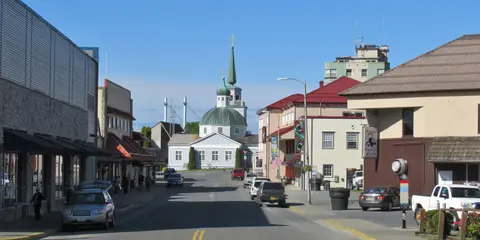
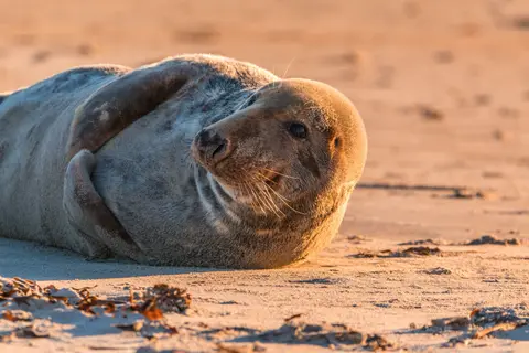
Sitka, gelegen aan de wilde westkust van Baranof Island in Zuidoost-Alaska, is een van de meest historisch resonante havens van de Pacific Northwest — een plek waar Russische Orthodoxe uivormige koepels oprijzen boven totempalen en het grote gematigde regenwoud naar de waterkant drukt. Het Sitka National Historical Park bewaart de plaats van de strijd in 1804 tussen Tlingit-krijgers en Russische kolonisten, naast een prachtige collectie monumentale palen. Walvisobservatie, zeekajakken tussen zeeotters, en het spotten van bruine beren in de omliggende wildernis definiëren de buitenervaring. Van mei tot september biedt de meest toegankelijke en heldere omstandigheden.
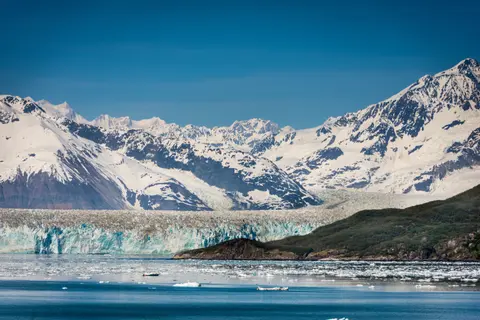
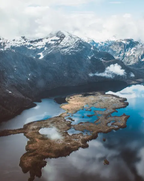
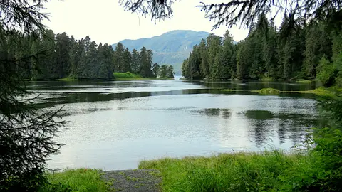
De Hubbardgletsjer, bekend als de "Galloping Glacier," is een adembenemend natuurwonder in Oost-Alaska, dat bezoekers betovert met zijn verbluffende ijsformaties en wilde dieren. Een must-do ervaring is het getuige zijn van het afkalven van de gletsjer en het proeven van lokale delicatessen zoals Dungenesskrab en rendiervlees in het nabijgelegen Skagway. De beste tijd om te bezoeken is in de zomermaanden wanneer het weer milder is en de wilde dieren overvloedig zijn.
The Hubbard Glacier is the largest, and one of the most spectacular tidewater glaciers in North America. Its ice cliffs, some 400’ (121 m) tall, calve icebergs into the fjord, which may frequently be larger than a five-story building. The glacier’s surface is creased and contorted, resembling the wrinkled skin of a giant elephant. Records show it has been growing in thickness and advancing since 1895. This stands in stark contrast to other glaciers around the world, most of which have been receding during the past century. In 2002, the glacier blocked Russell Fjord for two and a half months, raising water levels 61’ (18 m) and threatening local communities with flooding. Nutrient-rich waters along the glacier face attract many species. Gulls and kittiwake colonies adorn smaller islands and harbor seals patrol the icy waters. In 1890, Israel Russell explored the area of Yakutat Bay and Hubbard Glacier, naming it after Gardiner G. Hubbard, a financier of his expedition and a founder and the first president of the National Geographic Society. VIEW CRUISES
De Inian-eilanden zijn een wilde, onbewoonde cluster bij de ingang van Alaska's Cross Sound, beroemd om buitengewone ontmoetingen met wilde dieren, waaronder bultrugwalvissen die in bubbels voeden en enorme Steller-zeelionen kolonies. Must-dos zijn onder andere Zodiac-excursies langs de rotsachtige kusten van de eilanden, het bekijken van coöperatieve walvisvoeding, en het verkennen van getijdenpoelen vol met zeeleven. Bezoek van juli tot augustus voor de piek walvisactiviteit en de beste zeeomstandigheden.
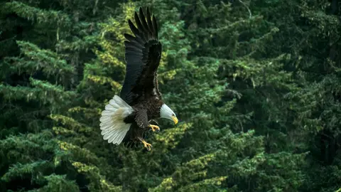
Haines is een authentieke Alaskaanse stad aan de diepste fjord van Noord-Amerika, de thuisbasis van 's werelds grootste verzameling zeearenden — tot vierduizend vogels langs de Chilkat-rivier — en een bloeiende kunstgemeenschap die de Tlingit-culturele tradities behoudt. Bezoek van juni tot augustus via Cunard of Lindblad voor gletsjerhelikopterlandingen en kustwandelingen, of van oktober tot februari voor het buitengewone arendspectakel dat Haines tot het best bewaarde geheim van Alaska maakt.
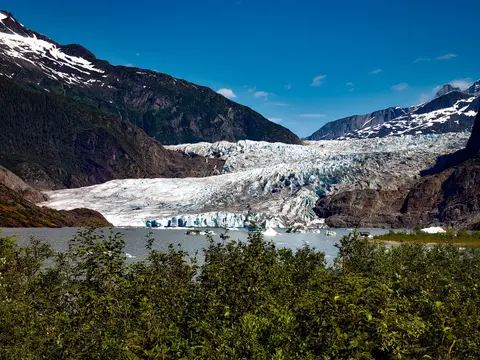
De enige staatshoofdstad van Amerika die niet per weg bereikbaar is, Juneau beloont de reis met een wildernisgrootheid die weinige steden op aarde kunnen evenaren. De Mendenhall-gletsjer — een levende rivier van oude ijs — ligt op slechts vijftien minuten van het centrum, waar watervliegtuigen boven een waterfront dartelen dat wordt geflankeerd door met sparren bedekte bergen die recht in de zee duiken. De must-do ervaring is een helikopterlanding op de ijsveld of een walvisspot-excursie in Stephens Passage, waar bultruggen in verbazingwekkende nabijheid breken. Juneau is het warmst van juni tot augustus, hoewel zelfs zomerse dagen de beroemde regen van Zuidoost-Alaska kunnen brengen die het regenwoud perpetueel stralend houdt.
Tracy Arm is een adembenemende 30 mijl lange fjord in Alaska's Tongass National Forest, beroemd om zijn dramatische landschappen en overvloedige wilde dieren. Must-do ervaringen zijn onder andere het cruisen door de fjord om kalvende gletsjers te bekijken en het genieten van lokale zeevruchten zoals gerookte zalm. Het beste seizoen om te bezoeken is tijdens de zomermaanden wanneer het gebied levendig en toegankelijk is.
Wrangell is een van de meest authentieke havens in de Inside Passage van Alaska, waar Tlingit-erfgoed, oude petroglyphen en wereldklasse wildlife samenkomen bij de monding van de machtige Stikine-rivier. Essentiële ervaringen zijn het jetbootvaren naar de LeConte-gletsjer, het kijken naar beren die vissen bij Anan Creek, en het proeven van lokaal gerookte zalm. Juli en augustus bieden de beste zalmloop en berenobservatie.
Misty Fjords National Monument is een 930.000 hectare groot wildernisgebied in Zuidoost-Alaska, waar steile granieten kliffen oprijzen uit spiegelgladde fjorden door eeuwige sluiers van mist en wolken. Must-dos zijn onder andere kajakken door stille fjordarmen, zodiac-cruisen langs watervallen en de vulkanische New Eddystone Rock, en het spotten van beren, adelaars en orka's in de ongerepte kanalen. Van mei tot september is het bezoekseizoen, met regen die bijdraagt aan de etherische sfeer van het monument.
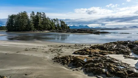
Prince Rupert, een historische spoorwegterminus aan de noordkust van British Columbia, betovert bezoekers met zijn diepe Tsimshian-erfgoed, wereldklasse heilbotvisserij en mistige regenwoudscenery langs de Inside Passage. Proef vers gerookte zalm aan de waterkant en verken de North Pacific Cannery, de oudste nog bestaande conservenfabriek van Canada, voor een levendige ontmoeting met de maritieme ziel van de haven. De beste tijd om te bezoeken is van juni tot augustus, wanneer langere dagen de beroemde regenval temperen en de activiteit van wildlife langs de kust op zijn hoogtepunt is.
Grenville Channel is a long, well-protected channel along the northern British Columbia coast between the large Pitt Island and the mainland. It is an important shipping lane, and you are likely to see ships of many different types and sizes as you pass through. The shores are mountainous on both sides, with two notable peaks about halfway through, Mt. Batchellor on the east side and Mt. Saunders on Pitt Island to the west. There are a number of Indian Reserves and Marine Parks in the mountains and narrow waterways off the channel.
Whale Channel is a picturesque waterway separating Gil Island from Princess Royal Island in British Columbia’s Inside Passage. Surrounded by snow-capped mountain ranges and teeming with marine life, It is a diversion from the main shipping lane, located roughly halfway between Prince Rupert and the First Nations village of Klemtu. VIEW CRUISES Skip Footer Content About Us
The Princess Royal Channel separates the largest island along British Columbia’s coast from the mainland. It is located roughly halfway between Bella Bella in the south and Prince Rupert in the north, in one of the province’s most remote areas. Princess Royal island was named in 1788 by Captain Charles Duncan, in honor of his ship, the Princess Royal. The island is uninhabited, although there are two small villages in the channel, the First Nations community of Klemtu on Swindle Island and Hartley Bay on the mainland. Wildlife, by contrast, is plentiful, including Kermode, black and grizzly bears, deer, wolves and foxes. Golden and bald eagles nest in the region, as well as the endangered marbled murrelet. In the waters, there are abundant salmon, elephant seals, whales, orcas and dolphins.
Alert Bay, Canada is een unieke havenstad waar een diep cultureel erfgoed samenkomt met een authentieke lokale sfeer, opgenomen in de reisroutes van HX Expeditions. Must-do ervaringen zijn onder andere een wandeling door het historische centrum om het gelaagde architectonische erfgoed te ervaren, en het ontdekken van de regionale culinaire tradities in een lokaal favoriet etablissement buiten het havengebied. De beste tijd om te bezoeken is van juni tot augustus, wanneer de zomermaanden de warmste temperaturen en de langste dagen met zich meebrengen.
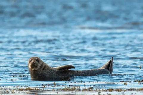
Johnstone Strait is a well-protected shipping route passing 68 miles/110 km along the northeast shore of Vancouver Island between the island and the mainland of British Columbia. The strait is between 1 ½ miles and 3 miles wide, and leads from the broad Georgia Strait through a narrow channel called Discovery Passage. The strait was named by Vancouver in 1792 for James Johnstone, the master of one of his tenders during the survey expedition that revealed Vancouver Island to be an island. There are no cities or towns on the strait. The Johnstone Strait is the summer range of a large pod of seasonally resident orcas which are frequently seen in the area. VIEW CRUISES Skip Footer Content About Us Our Company News Careers Contact Us Video Gallery Accessibility Seabourn Club Seabourn Referral Program Travel Resources
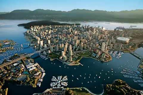
Geperst tussen de Stille Oceaan en de Coast Mountains, is Vancouver de natuurlijke toegangspoort tot de Inside Passage van Alaska — een stad waar gematigd regenwoud ontmoet glazen torens en waar Dungeness-kreeft en wilde sockeye-zalm een Pacific Rim-keuken definiëren die met elke in Noord-Amerika kan concurreren. Wandel over de 22 kilometer lange zeewering van Stanley Park, verdwaal in de markt van Granville Island en neem de veerboot naar de Edwardiaanse pracht van Victoria. Het cruiseseizoen naar Alaska bereikt zijn hoogtepunt van mei tot september, waardoor Vancouver een ideaal startpunt is voor een van de grootste oceaanreizen ter wereld.
Day 1
Geperst tussen de Stille Oceaan en de Coast Mountains, is Vancouver de natuurlijke toegangspoort tot de Inside Passage van Alaska — een stad waar gematigd regenwoud ontmoet glazen torens en waar Dungeness-kreeft en wilde sockeye-zalm een Pacific Rim-keuken definiëren die met elke in Noord-Amerika kan concurreren. Wandel over de 22 kilometer lange zeewering van Stanley Park, verdwaal in de markt van Granville Island en neem de veerboot naar de Edwardiaanse pracht van Victoria. Het cruiseseizoen naar Alaska bereikt zijn hoogtepunt van mei tot september, waardoor Vancouver een ideaal startpunt is voor een van de grootste oceaanreizen ter wereld.
Day 2
The Queen Charlotte Sound lies between the Queen Charlotte Strait, which winds between Vancouver Island and the British Columbia mainland in the south, and Hecate Strait, which is northward, adjacent to the Haida Gwaii Islands off the Pacific coast of British Columbia. It is a broad reach in the long shipping route called the Inside Passage threading the myriad islands stretching from Washington’s Puget Sound to Alaska.
Day 3
Ketchikan kleeft aan de beboste kust van Revillagigedo Island in de zuidoostelijke panhandle van Alaska — een stad zo smal dat de lokale bevolking grapt dat het drie mijl lang en drie blokken breed is. Geëerd door de Tlingit-bevolking gedurende millennia als een plek van overvloedige zalm, wordt het vandaag de dag gevierd als de Totem Pole Capital of the World: de collecties in Saxman Native Village en Totem Bight State Historical Park behouden de meest significante concentratie van deze monumentale kunstwerken ter wereld. Creek Street, een promenade van kleurrijke historische huizen gebouwd over Ketchikan Creek, mag niet worden gemist. De zomer (mei-september) brengt het beste weer, met zalm die in de kreken beneden zwemt.
Day 4
Sitka, gelegen aan de wilde westkust van Baranof Island in Zuidoost-Alaska, is een van de meest historisch resonante havens van de Pacific Northwest — een plek waar Russische Orthodoxe uivormige koepels oprijzen boven totempalen en het grote gematigde regenwoud naar de waterkant drukt. Het Sitka National Historical Park bewaart de plaats van de strijd in 1804 tussen Tlingit-krijgers en Russische kolonisten, naast een prachtige collectie monumentale palen. Walvisobservatie, zeekajakken tussen zeeotters, en het spotten van bruine beren in de omliggende wildernis definiëren de buitenervaring. Van mei tot september biedt de meest toegankelijke en heldere omstandigheden.
Day 5
De Hubbardgletsjer, bekend als de "Galloping Glacier," is een adembenemend natuurwonder in Oost-Alaska, dat bezoekers betovert met zijn verbluffende ijsformaties en wilde dieren. Een must-do ervaring is het getuige zijn van het afkalven van de gletsjer en het proeven van lokale delicatessen zoals Dungenesskrab en rendiervlees in het nabijgelegen Skagway. De beste tijd om te bezoeken is in de zomermaanden wanneer het weer milder is en de wilde dieren overvloedig zijn.
The Hubbard Glacier is the largest, and one of the most spectacular tidewater glaciers in North America. Its ice cliffs, some 400’ (121 m) tall, calve icebergs into the fjord, which may frequently be larger than a five-story building. The glacier’s surface is creased and contorted, resembling the wrinkled skin of a giant elephant. Records show it has been growing in thickness and advancing since 1895. This stands in stark contrast to other glaciers around the world, most of which have been receding during the past century. In 2002, the glacier blocked Russell Fjord for two and a half months, raising water levels 61’ (18 m) and threatening local communities with flooding. Nutrient-rich waters along the glacier face attract many species. Gulls and kittiwake colonies adorn smaller islands and harbor seals patrol the icy waters. In 1890, Israel Russell explored the area of Yakutat Bay and Hubbard Glacier, naming it after Gardiner G. Hubbard, a financier of his expedition and a founder and the first president of the National Geographic Society. VIEW CRUISES
Day 6
De Inian-eilanden zijn een wilde, onbewoonde cluster bij de ingang van Alaska's Cross Sound, beroemd om buitengewone ontmoetingen met wilde dieren, waaronder bultrugwalvissen die in bubbels voeden en enorme Steller-zeelionen kolonies. Must-dos zijn onder andere Zodiac-excursies langs de rotsachtige kusten van de eilanden, het bekijken van coöperatieve walvisvoeding, en het verkennen van getijdenpoelen vol met zeeleven. Bezoek van juli tot augustus voor de piek walvisactiviteit en de beste zeeomstandigheden.
Day 7
Haines is een authentieke Alaskaanse stad aan de diepste fjord van Noord-Amerika, de thuisbasis van 's werelds grootste verzameling zeearenden — tot vierduizend vogels langs de Chilkat-rivier — en een bloeiende kunstgemeenschap die de Tlingit-culturele tradities behoudt. Bezoek van juni tot augustus via Cunard of Lindblad voor gletsjerhelikopterlandingen en kustwandelingen, of van oktober tot februari voor het buitengewone arendspectakel dat Haines tot het best bewaarde geheim van Alaska maakt.
Day 8
De enige staatshoofdstad van Amerika die niet per weg bereikbaar is, Juneau beloont de reis met een wildernisgrootheid die weinige steden op aarde kunnen evenaren. De Mendenhall-gletsjer — een levende rivier van oude ijs — ligt op slechts vijftien minuten van het centrum, waar watervliegtuigen boven een waterfront dartelen dat wordt geflankeerd door met sparren bedekte bergen die recht in de zee duiken. De must-do ervaring is een helikopterlanding op de ijsveld of een walvisspot-excursie in Stephens Passage, waar bultruggen in verbazingwekkende nabijheid breken. Juneau is het warmst van juni tot augustus, hoewel zelfs zomerse dagen de beroemde regen van Zuidoost-Alaska kunnen brengen die het regenwoud perpetueel stralend houdt.
Day 9
Tracy Arm is een adembenemende 30 mijl lange fjord in Alaska's Tongass National Forest, beroemd om zijn dramatische landschappen en overvloedige wilde dieren. Must-do ervaringen zijn onder andere het cruisen door de fjord om kalvende gletsjers te bekijken en het genieten van lokale zeevruchten zoals gerookte zalm. Het beste seizoen om te bezoeken is tijdens de zomermaanden wanneer het gebied levendig en toegankelijk is.
Day 10
Wrangell is een van de meest authentieke havens in de Inside Passage van Alaska, waar Tlingit-erfgoed, oude petroglyphen en wereldklasse wildlife samenkomen bij de monding van de machtige Stikine-rivier. Essentiële ervaringen zijn het jetbootvaren naar de LeConte-gletsjer, het kijken naar beren die vissen bij Anan Creek, en het proeven van lokaal gerookte zalm. Juli en augustus bieden de beste zalmloop en berenobservatie.
Day 11
Misty Fjords National Monument is een 930.000 hectare groot wildernisgebied in Zuidoost-Alaska, waar steile granieten kliffen oprijzen uit spiegelgladde fjorden door eeuwige sluiers van mist en wolken. Must-dos zijn onder andere kajakken door stille fjordarmen, zodiac-cruisen langs watervallen en de vulkanische New Eddystone Rock, en het spotten van beren, adelaars en orka's in de ongerepte kanalen. Van mei tot september is het bezoekseizoen, met regen die bijdraagt aan de etherische sfeer van het monument.
Day 12
Prince Rupert, een historische spoorwegterminus aan de noordkust van British Columbia, betovert bezoekers met zijn diepe Tsimshian-erfgoed, wereldklasse heilbotvisserij en mistige regenwoudscenery langs de Inside Passage. Proef vers gerookte zalm aan de waterkant en verken de North Pacific Cannery, de oudste nog bestaande conservenfabriek van Canada, voor een levendige ontmoeting met de maritieme ziel van de haven. De beste tijd om te bezoeken is van juni tot augustus, wanneer langere dagen de beroemde regenval temperen en de activiteit van wildlife langs de kust op zijn hoogtepunt is.
Day 13
Grenville Channel is a long, well-protected channel along the northern British Columbia coast between the large Pitt Island and the mainland. It is an important shipping lane, and you are likely to see ships of many different types and sizes as you pass through. The shores are mountainous on both sides, with two notable peaks about halfway through, Mt. Batchellor on the east side and Mt. Saunders on Pitt Island to the west. There are a number of Indian Reserves and Marine Parks in the mountains and narrow waterways off the channel.
Whale Channel is a picturesque waterway separating Gil Island from Princess Royal Island in British Columbia’s Inside Passage. Surrounded by snow-capped mountain ranges and teeming with marine life, It is a diversion from the main shipping lane, located roughly halfway between Prince Rupert and the First Nations village of Klemtu. VIEW CRUISES Skip Footer Content About Us
The Princess Royal Channel separates the largest island along British Columbia’s coast from the mainland. It is located roughly halfway between Bella Bella in the south and Prince Rupert in the north, in one of the province’s most remote areas. Princess Royal island was named in 1788 by Captain Charles Duncan, in honor of his ship, the Princess Royal. The island is uninhabited, although there are two small villages in the channel, the First Nations community of Klemtu on Swindle Island and Hartley Bay on the mainland. Wildlife, by contrast, is plentiful, including Kermode, black and grizzly bears, deer, wolves and foxes. Golden and bald eagles nest in the region, as well as the endangered marbled murrelet. In the waters, there are abundant salmon, elephant seals, whales, orcas and dolphins.
Day 14
Alert Bay, Canada is een unieke havenstad waar een diep cultureel erfgoed samenkomt met een authentieke lokale sfeer, opgenomen in de reisroutes van HX Expeditions. Must-do ervaringen zijn onder andere een wandeling door het historische centrum om het gelaagde architectonische erfgoed te ervaren, en het ontdekken van de regionale culinaire tradities in een lokaal favoriet etablissement buiten het havengebied. De beste tijd om te bezoeken is van juni tot augustus, wanneer de zomermaanden de warmste temperaturen en de langste dagen met zich meebrengen.
Johnstone Strait is a well-protected shipping route passing 68 miles/110 km along the northeast shore of Vancouver Island between the island and the mainland of British Columbia. The strait is between 1 ½ miles and 3 miles wide, and leads from the broad Georgia Strait through a narrow channel called Discovery Passage. The strait was named by Vancouver in 1792 for James Johnstone, the master of one of his tenders during the survey expedition that revealed Vancouver Island to be an island. There are no cities or towns on the strait. The Johnstone Strait is the summer range of a large pod of seasonally resident orcas which are frequently seen in the area. VIEW CRUISES Skip Footer Content About Us Our Company News Careers Contact Us Video Gallery Accessibility Seabourn Club Seabourn Referral Program Travel Resources
Day 15
Geperst tussen de Stille Oceaan en de Coast Mountains, is Vancouver de natuurlijke toegangspoort tot de Inside Passage van Alaska — een stad waar gematigd regenwoud ontmoet glazen torens en waar Dungeness-kreeft en wilde sockeye-zalm een Pacific Rim-keuken definiëren die met elke in Noord-Amerika kan concurreren. Wandel over de 22 kilometer lange zeewering van Stanley Park, verdwaal in de markt van Granville Island en neem de veerboot naar de Edwardiaanse pracht van Victoria. Het cruiseseizoen naar Alaska bereikt zijn hoogtepunt van mei tot september, waardoor Vancouver een ideaal startpunt is voor een van de grootste oceaanreizen ter wereld.


Our cruise specialists can help you find the perfect cabin and the best available pricing.
(+886) 02-2721-7300Contact Advisor